Mount Edwards 13,850'
Mount Edwards from the south. Photo: Rob Writz
Mount Edwards is a proud Centennial 13er located on the Continental Divide. It is the highest peak described on this website with the exception of Grays Peak and Torreys Peak. Edwards has ski mountaineering routes on all sides and the mountain continues to reveal new routes year after year. The South Face of Edwards holds the classic “Edwardian” couloir and a quick approach from the Horseshoe Basin Trailhead in early summer. The broad East Slopes combine well with a full day exploration of McClellan Mountain or Argentine Peak. The complicated North Face holds numerous routes including Goatfinger, a mountaineering route on the western end of the face, and a steep couloir in the center of the face recently skied by Chris Davenport (see our Resources page for a link to Centennial Skiers).
+ ROUTES
Route 1 - The Edwardian
- Rating: II D4
- Season: Spring
- Exposure: South
- Vertical: 1,380'
- Approach Elevations: 111,097' - 13,580'
- Approach Distance: From Horseshoe Basin TH: 2.3 miles
The Edwardian is classic Colorado couloir and a great destination for ski mountaineers who are beginning to transition from moderate slopes into couloirs. There is usually no cornice on this couloir and that can be helpful for aspiring chute climbers. The Edwardian faces south, but the lower portion of the route is shaded from a direct sun hit in the morning due to Mount Edward’s Southeast Ridge and South Face. The couloir itself is not too steep, and has a few twists and turns among rock walls and small spires. The chute fans out and terminates at a saddle between Edwards and the first of the sub-peaks leading to Grays Peak. It is about a quarter mile hike from the saddle to the summit of Mount Edwards. For a bigger day, consider climbing and skiing this after an early ascent and descent of Grays Peak’s Horseshoe Face. The Edwardian is often skiable through June.
Follow jeep road into Horseshoe Basin as far as you can delineate it. From the obvious parking at the Horseshoe Mine the road follows the bleached rocks of Peru Creek north into Horseshoe Basin. Once you round the eastern flank of Ruby Mountain and gain altitude in the basin you will be able to see The Edwardian directly to the north. Continue on the Peru Creek jeep road north, switchback left once and arrive at the end of the jeep road at approximately 12,000’. Climb the couloir. If you snowmobile into this area earlier in the spring you may be able to make it to the summer trailhead.

Mount Edwards east slope from the east. Photo: Rob Writz
Route 2 - East Slope
- Rating: III D2
- Season: Spring
- Exposure: East, Northeast
- Vertical: 2,000'
- Approach Elevations: 9,500' - 13,850'
- Approach Distance: From Leavenworth Creek TH: 7.6 miles
The broad East Slope of Mount Edwards is a gentle ski mountaineering goal far from the roads. It is a long ski up the Leavenworth Creek Valley in the winter and spring, but in late spring you may be able to drive a higher clearance four wheel drive vehicle up the road. The route itself is easy and usually is a connected snowfield from just below the summit to 11,800’. Later in the spring the snow on the slope splits into separate snow fields. To the skier’s right and further east along the ridge there are several northeast facing slopes that are a little steeper and fun descents. To the skier’s right of this there is a steeper bowl facing east and above Leavenworth Creek.
Depart the start of the Leavenworth Road at the trailhead description above. The first mile of the road is steep, crosses Leavenworth Creek, and reaches the old railroad grade around 10,000’. From here the road is straight forward and takes a mellow and long line southwest through the Leavenworth Creek valley. It is about 6 miles from the trailhead to the Leavenworth Creek Road’s switchback towards the Santiago Mine and the Santiago Bowl. Continue south past the Waldorf Mine and the broad East Slope is right above you. Climb from here 1.25 miles up the gentle slopes to the summit of Mount Edwards.

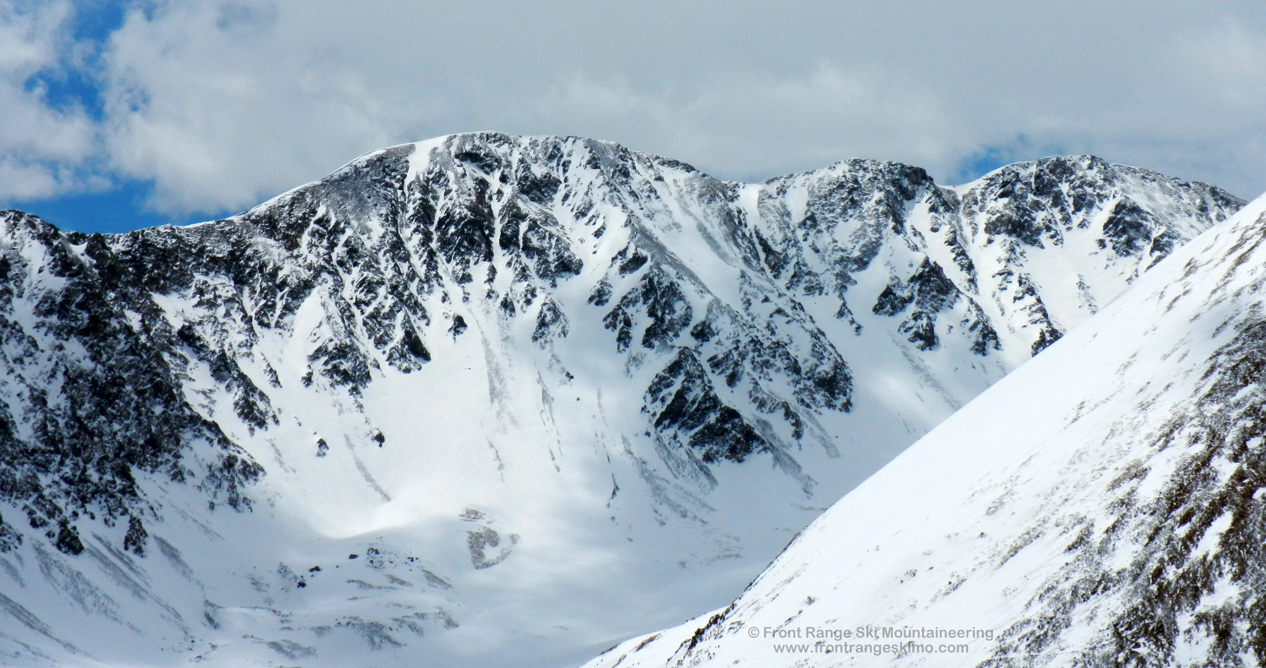
Mount Edwards North Face from the north.
Route 3 - North Face Couloir
- Rating: II D14
- Season: Spring
- Exposure: Northeast
- Vertical: 1,800'
- Approach Elevations: 11,250' - 13,800'
- Approach Distance: From Stevens Gulch Summer TH: 1.85 miles
The North Face of Mount Edwards is wide expanse of couloirs and cliffs that runs west to east for nearly a mile between the saddle shared with Grays Peak and the saddle shared with McClellan Mountain. There are numerous lines on this face and Front Range ski mountaineers continue to explore this area. You can get a good view of the face from the Stevens Gulch summer trailhead, and an even better view from the summit of Kelso Mountain. The North Face Couloir described here is a northeast facing line that starts just west of the summit. The upper portion is consistently steep and very challenging due to turns and alternating fall lines. The book “Climbing and Skiing Colorado’s Mountains” has a detailed description of the climb (see our Resources page for more information).
The approach to the North Face of Mount Edwards is straight forward. From the Stevens Gulch summer trailhead you will be able to see the majority of the North Face. Follow the line of the creek drainage descending from the north face. For most of the spring you can ski over snow in the creek bed or on strips paralleling the creek bed. At the base of the North Face is a broad apron leading to several couloirs on the face. You are aiming for the right side of the apron, and climbing to the left of a prominent rock buttress that descends lower on the mountain than any other buttress. Climb the apron at least half way up the mountain, and then bear right into the couloir. Another right turn higher up will then allow you to climb an increasingly steeper chute that terminates west of the summit.
+ TRAILHEAD
Stevens Gulch (9,900’ or 11,250’)
Stevens Gulch Trailhead is accessed via Exit 221 on Interstate 70. This is the Bakersville exit. Exit the interstate and proceed south to Road 321 (Stevens Gulch Road). Early in the spring during a good snow winter you may need to park just south of the interstate where the Stevens Gulch road turns east. There is a sharp turn to the west just up the road from here that is frequently blocked with snow. During the spring the snow on the road rapidly melts and the distance from the interstate exit to Stevens Gulch summer trailhead will vary significantly. There may be different starting points depending on the time of spring you are here. The Stevens Gulch summer trailhead is at the end of the road and is about 3 miles from Exit 221.
Horseshoe Basin Trailhead (11,097’)
The Horseshoe Basin Trailhead is located far up the Peru Creek Valley. This trailhead does not open until late spring or early summer, and it is a long ski in from the winter closure at the intersection of Montezuma Road and Peru Creek Road. Drive the Montezuma Road about 4.5 miles from its start at Loveland Pass Road (Highway 6) and the Keystone ski area to the intersection with the Peru Creek Road. If you arrive at the town of Montezuma you went too far. Turn around and go back down the hill and look right. Drive up the Peru Creek Road another 4.5 miles to the Horseshoe Basin Trailhead and where the road is closed in the summer.
Leavenworth Creek Trailhead (9,500’)
The Leavenworth Creek Trailhead is located at a major switchback on the Guanella Pass Road 2.5 miles south of Georgetown. The Leavenworth Road departs the Guanella Pass Road on an acute and steep angle. There is parking on the north side of the Guanella Pass Road switchback. Early in the spring you will need to park here and either ski or use a snowmobile to access Leavenworth Road. In the late spring and summer, depending on the amount of snow on the road in the forest, you may be able to drive a high clearance four-wheel drive vehicle towards the ghost town of Waldorf.
+ MAPS & PICTURES
Below we have included a link to a Google interactive map and a curated list of photos of the mountain.

Clicking on map above will open interactive Google map website