Jones Pass Backcountry Skiing
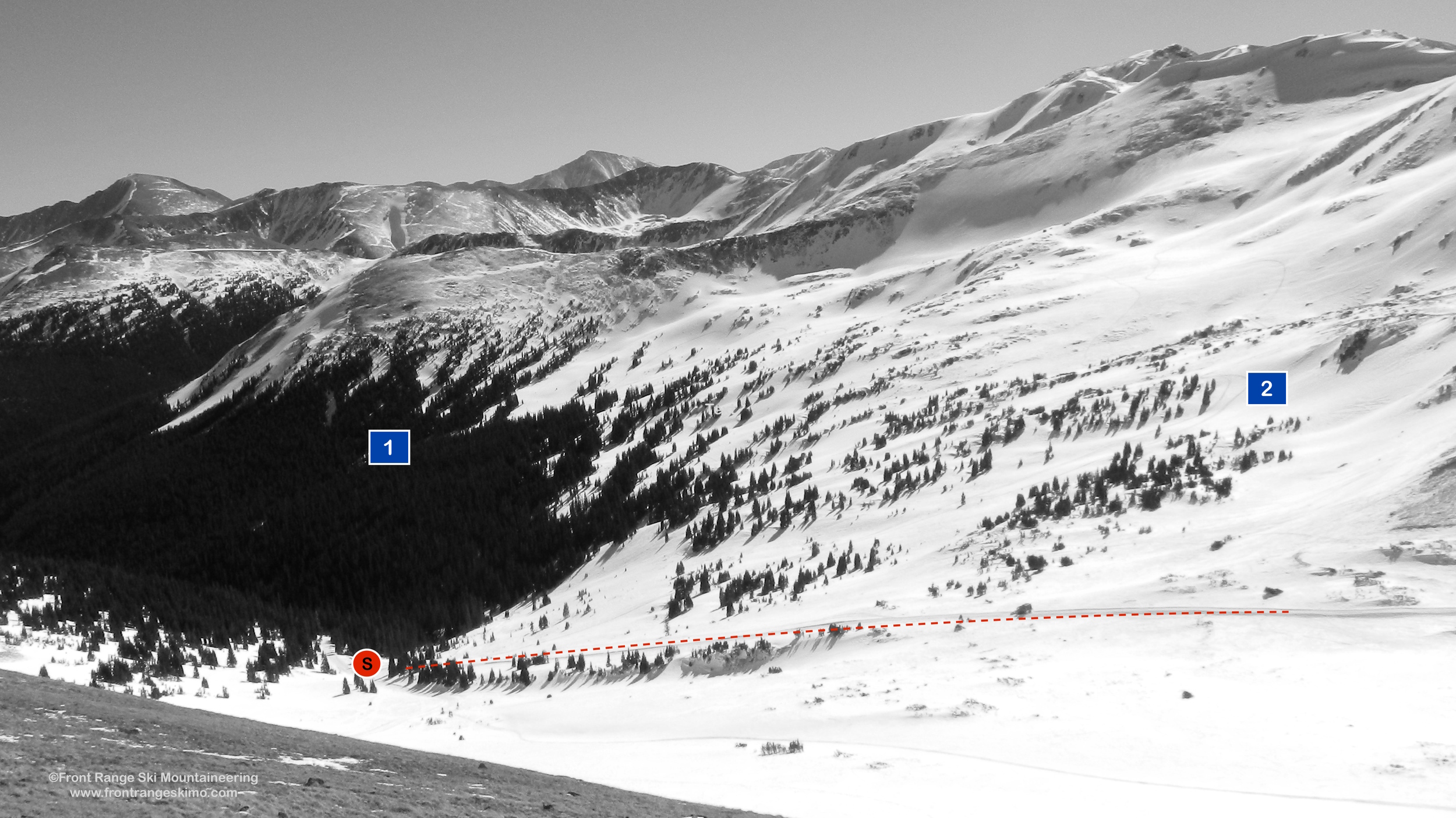
Jones Pass South from the north. Photo: Rob Writz
The Jones Pass area is a massive backcountry skiing zone that is more frequented by snowmobiles than backcountry skiers. A winter’s worth of exploration is awaiting you in Jones Pass. We have divided the Jones Pass descriptions into three areas: Jones Pass South, Point 12,118 Zone, and the West Fork Bowl.
This area has historically been frequented by snowmobiles, and recently Powder Addiction has a permit to operate its cat skiing operation on the terrain surrounding the Jones Pass area. If you want a non-motorized experience, go to Butler Gulch. Otherwise, be thankful for the packed skin track put in by the snowmobiles and the significant work the Powder Addiction team does to maintain these roads in the winter.
Note the names of the runs here do not coincide with the names that the Powder Addiction Guides use.
+ JONES PASS SOUTH ROUTES
- Season: Winter
- Summit Elevation: 11,900’
- Aspect: North
- Elevation Range: 10,465’ – 11,900’
- Vertical: 600’ – 1,000’
- Trailhead: Jones Pass (10,465’)
- Snowmobile Access: Snowmobiles are allowed in Jones Pass.
Skin Track:
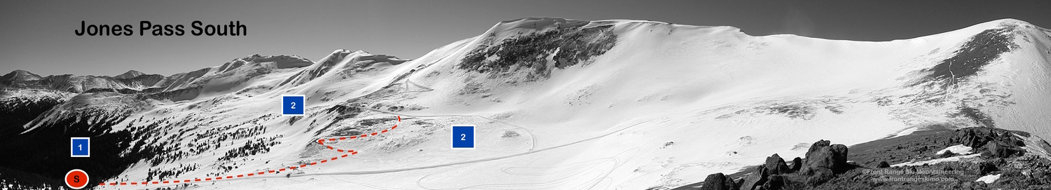
The skin track to Jones Pass South starts at the west end of the winter trailhead at the obvious Forest Service signs. Ski a hundred yards up the road, and there is a sign showing Jones Pass to the right and Butler Gulch to the left.
The skin track follows the Jones Pass Road into the Jones Pass Bowl. The path of the jeep road is obvious, especially after snowmobiles or a snow cat have gone ahead. The road climbs eight tenths of a mile to a clearing below Point 12,118. [39.7793, -105.8638]. At this clearing the jeep road begins climbing and then switchbacks to the south across the base of Point 12,118 and then 1.25 miles to Jones Pass Bowl.
Additionally, there is a short cut that circumvents the Jones Pass Jeep road and goes into Jones Pass Bowl following the line of creek that drains the bowl. At approximately .65 miles on the ski in on Jones Pass Road, just past where the road turns to the north, there is an entry point west into the wood that follows the line of an old trail. [39.776944, -105.863889]. This trail climbs west across the base of Point 12,118 then joins the creek to climb to Jones Pass Bowl near the road’s switchbacks.
Both Jones Pass Road and the short cut bring you to the wide expanse of Jones Pass Bowl. Traverse across the bowl to access your run.
Exit
Skiing into the bottom of Jones Pass Bowl has the potential to access the short cut trail described above. If you miss this, follow the creek bed into the flats and then climb back to the Jones Pass Road. The further you traverse into Jones Pass Bowl the more likely you are to miss the short cut.
Routes:
1 - Fingers - The Fingers are a series of glades dropping off of the northwest side of Point 12,085 into creek beds.
2 - Jones Pass Bowl - This expansive north-facing bowl has numerous moderate options at and below tree line. Softer snow usually awaits in the trees.
+ JONES PASS 12,118 ZONE

- Season: Winter
- Summit Elevation: 11,900’ (below 12,118’)
- Aspect: Southeast East, Northeast
- Elevation Range: 10,465’ – 11,900’
- Vertical: 900’
- Trailhead: Jones Pass (10,465’)
- Snowmobile Access: Snowmobiles are allowed in Jones Pass.
Skin Track:
The skin track to the Point 12,118 area starts at the west end of the winter trailhead at the obvious Forest Service signs. Ski a hundred yards up the road, and there is a sign showing Jones Pass to the right and Butler Gulch to the left.
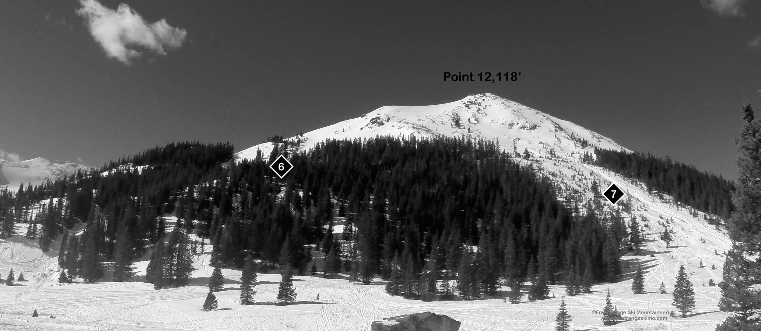
The skin track follows the Jones Pass Road, and the path of the jeep road is obvious, especially after snowmobiles or a snow cat have gone ahead. The road climbs eight tenths of a mile to a clearing below Point 12,118. [39.7793, -105.8638]. At this clearing the jeep road begins climbing and then switchbacks to the south across the base of Point 12,118 and the switchbacks several times to tree line below Point 12,118’ (about 2 miles from the trailhead). At this point you can access the runs dropping southeast, east, and north from below Point 12,118.
Exit:
These runs intersect the Jones Pass Road or the jeep road to the West Fork Bowl.
3 - Southwest Trees – A quick glade run to the Jones Pass Road, and beyond to the creek and short cut noted in Jones Pass South.
4 - Solar Bowl – This outstanding line gets a lot of sun so be aware of avalanche potential of fresh snow on top of persistent slabs made of glazed layers.
5 - Jones Trees – The attractive tree run you see from the clearing on the approach.
6 - Point 12,118 Northeast Chutes– A series of gulleys drops northeast and back to the clearing on the approach.
7 – 12,118 Slide Path – Northeast facing avalanche path frequented by high marking snowmobiles.
8 -Vasquez Glades – This is a wide expanse of glades facing south and southwest. From the clearing on the approach these are to the north, right, and a few minutes further up the road towards the West Fork Bowl.
+ WEST FORK BOWL ROUTES

- Season: Winter
- Summit Elevation: 12,673’
- Aspect: East, Southeast
- Elevation Range: 10,465’ – 12,673’
- Vertical: 600’ – 1,200’
- Trailhead: Jones Pass (10,465’)
- Snowmobile Access: Snowmobiles are allowed in Jones Pass
Skin Track:
The skin track to the West Fork Bowl starts at the west end of the winter trailhead at the obvious Forest Service signs. Ski a hundred yards up the road, and there is a sign showing Jones Pass to the right and Butler Gulch to the left.
The skin track follows the Jones Pass Road. The path of the jeep road is obvious, especially after snowmobiles or a snow cat have gone ahead. The road climbs eight tenths of a mile to a clearing below Point 12,118. [39.7793, -105.8638]. At this clearing separate from the Jones Pass Road and head north following a jeep road. This is well defined once Powder Addiction establishes the snow cat road. Continue into the West Fork Bowl, approximately 2.5 miles from the trailhead. [39.7948, -105.8833]
Exit:
All of these routes make their way back to the snowcat road used on the approach.
Routes:
9 - Highmark Glades – On the way to the West Fork Bowl and past Point 12,118 are short northeast facing glades.
10 - Peak 12,673 Bowl – The bowls below 12,673 drop into dispersed trees reminiscent of Chair 8 at Loveland Ski Area.
11 - Peak 12,666 Bowl – Steeper chutes drop directly from Peak 12,666 into the West Fork Bowl.
12 - Vasquez Saddle – This is a lower angled bowl that accesses the saddle between the West Fork of Clear Creek and Vasquez Creek.
+ TRAILHEAD
Jones Pass (10,465’)
Jones Pass and Butler Gulch share a winter trailhead. If you are coming from Interstate 70, leave the highway at Exit 232 for Winter Park and Highway 40. Drive slowly through the town of Empire as the town strictly enforces the 35 mph speed limit. From the Interstate 70 exit, drive 7.2 miles to the first major switchback on Berthoud Pass. Turn left on Henderson Mine Road to Jones Pass. Drive to the Henderson Mine complex and to your right is a small road leading 800 feet to the winter trailhead. [39.7712, -105.8548] If there has been significant snow, this small road may not be plowed and not passable. To the left is a large lot that you can park in. This lot is commonly used by snowmobiles. The Jones Pass and Butler Gulch winter trailhead serves both motorized and non-motorized winter users. Most trucks and trailers park at the lower lot near the mine, or in the first of the upper two lots.
+ MAPS & PICTURES
Below we have included a link to a Google interactive map and a curated list of photos of the mountain.

Clicking on map above will open interactive Google map website