Mount Toll, 12,979'
Mount Toll Overview from the East. Photo: Rob Writz
Mount Toll is a beautiful peak. The mountain’s prominent shape, framed by the vertical north ridge, is distinct from vantages both east and west. The best views of Mount Toll from the lower Front Range are east of Boulder on the high plains. Mount Toll is a very popular spring and summer ski descent and also a popular mountaineering goal.
+ ROUTES
1 – Southeast Face
- Rating: II, D7
- Season: Spring, Summer
- Exposure: Southeast
- Vertical: 1,660’
- Approach Elevations: 10,080' - 12,979'
- Approach Distance: From Mitchell Lake TH: 3.5 miles, From Brainard Lake Gateway TH: 7 miles
The Southeast Face of Mt Toll is the classic Indian Peaks descent. It is sought by many Front Range skiers and if you are skiing this on a weekend day during the spring do not expect a solo wilderness adventure. You may even encounter skiers that are camped at the summit! This route can be skied well into the summer. Mt Toll is a great introduction to ski mountaineering including a descent directly from the summit, a wide face for big turns and beautiful views of the Indian Peaks.
Ski or hike approximately 2.5 miles to Blue Lake from the Mitchell Lake Trailhead. The Mitchell Lake and Blue Lake summer trail will lead you to Blue Lake, but it can be hard to follow when the trail is covered in snow. An alternative is to skirt to southwest side of Mitchell Lake and proceed west and southwest through low angle and open terrain to regain the approximate line of the trail. If Blue Lake is frozen, carefully ski across it to the base of a wide and low angle couloir at the southwest corner of the lake. From here, make several switchbacks to the bowl at 12,000’ below the South Face of Mt Toll. Climb the South Face to the summit.
+ TRAILHEAD
Brainard Lake Gateway Trailhead (10,000), Mitchell Lake Trailhead (10,480’)
Brainard Lake Gateway Trailhead is the access point to the Mitchell Lake and Long Lake Trailheads. The road from the Gateway Trailhead to Mitchell Lake and Long Lake may not be open to cars until mid-June. Because of this closure the spring and early summer ski adventures in the Brainard Lake area are launched from here. The spacious trailhead at the Gateway is host to a large gathering of backcountry skiers and mountaineers in the pre-dawn hours on spring weekends. When the road opens in mid-June there is an access fee into the Brainard Lake Recreation Area. Access the Brainard Lake Gateway Trailhead on Brainard Lake Drive west of the town of Ward on Highway 72.
Gear up and ski, hike or ride your bike to the Mitchell Lake Trailhead. It is about 3.5 miles from the Gateway on the Brainard Lake Road to the right turn leading to the Mitchell Lake Trailhead and the Long Lake Trailhead. Go about a half mile straight up this road to the Mitchell Lake Trailhead (the left turn is to Long Lake Trailhead). You can check the status of the Brainard Lake Road at the USFS Roosevelt National Forest Boulder Ranger District Road Status website.
+ MAPS & PICTURES
Below we have included a link to Front Range Skimo's master map. The routes on the map are approximations, and are not intended for use as a GPX track. To the right are a curated list of photos of the mountain.
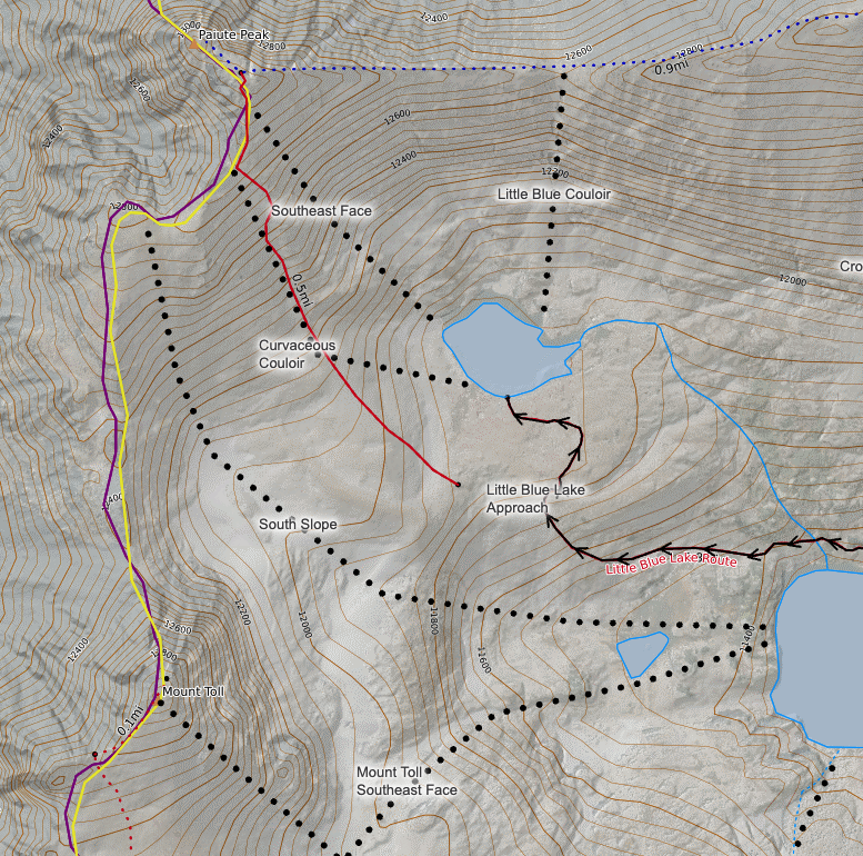
Clicking on map above will open interactive Caltopo map website.


