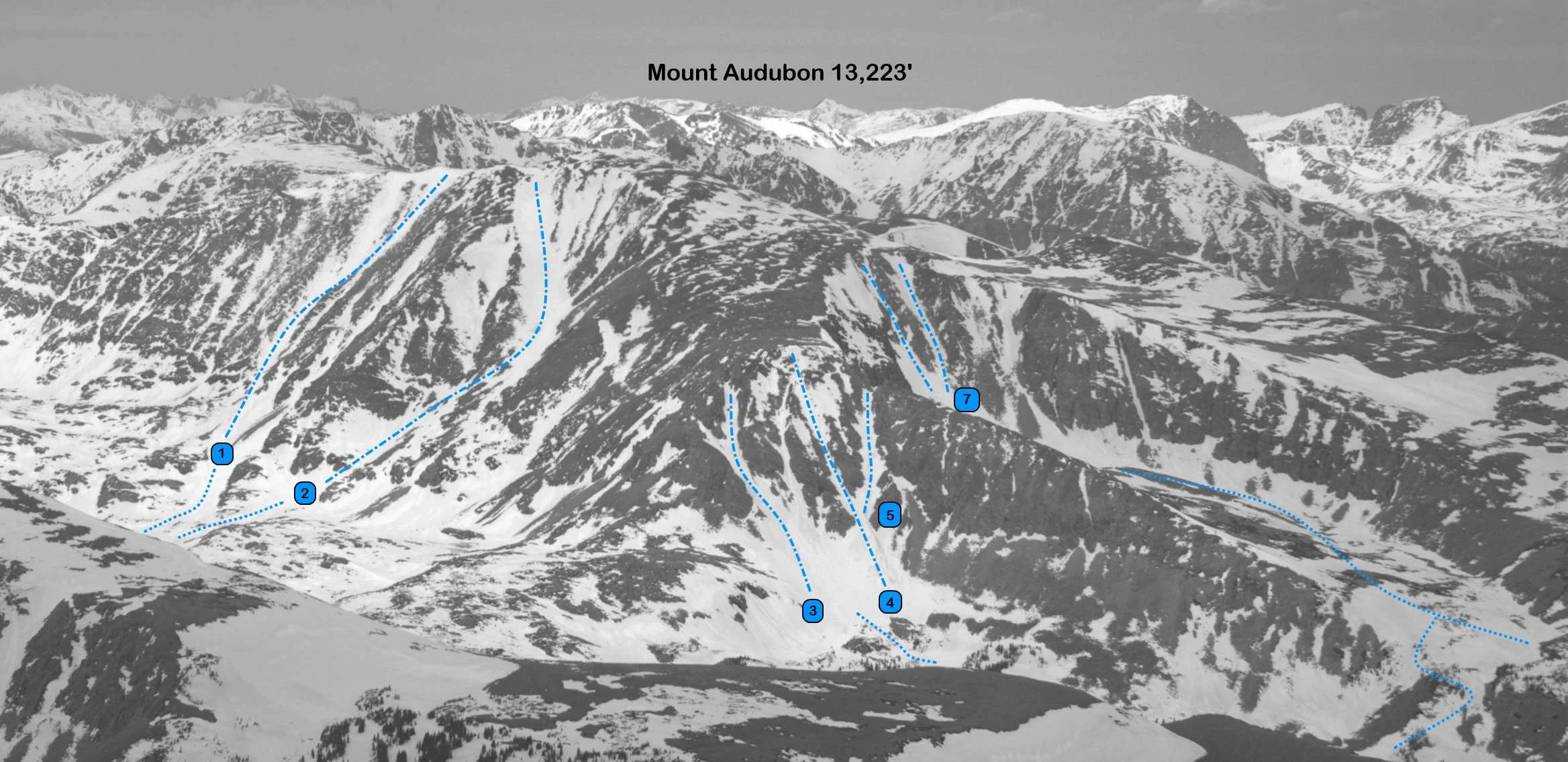
Mount Audubon, 13,233'
Mount Audubon from the southeast. Photo: Rob Writz
Mount Audubon is a massive, round hulk of a mountain east of the Continental Divide. It reigns over the north side of Blue Lake, but is often dismissed by mountaineers because of its gentle shape. Ski mountaineers know better, and Mount Audubon is one of the more popular targets from the Brainard Lake Gateway Trailhead in the spring. Excellent ski descents ring Audubon on the north, east, and south sides of the mountain.
+ ROUTES
Routes 1-5 have a shared approach to Blue Lake
The Crooked Couloir, South Face, and Autobahn Couloirs share a common approach to Blue Lake. Blue Lake is accessed from the Mitchell Lake Trailhead on the Brainard Lake Road. Ski approximately 2.5 miles from the Mitchell Lake Trailhead to Blue Lake. The Mitchell Lake and Blue Lake summer trail will lead you to Blue Lake, but it can be hard to follow when the trail is covered in snow. An alternative is to skirt to southwest side of Mitchell Lake and proceed west and southwest through low angle and open terrain to regain the approximate line of the trail.
Route 1 - Crooked Couloir
- Rating: II D8
- Season: Spring
- Exposure: South
- Vertical: 1,600’
- Approach Elevations: 10,080' - 13,233'
- Approach Distance: From Mitchell Lake TH: 3.5 miles, From Brainard Lake Gateway TH: 7.5 miles The Crooked Couloir is a popular route on Mount Audubon. This is a moderate route with a steep section near the crook and great vertical that ends at Blue Lake. Note that the crook deteriorates later in the spring and early summer, and some descents are done on the tiny snow sliver that remains in the crooked part. Follow the approach from Mitchell Lake Trailhead to Blue Lake. From Blue Lake, skirt the north side of the lake and directly climb the couloir
Route 2 - South Face
- Rating: II D6
- Season: Spring
- Exposure: South
- Vertical: 1,600’
- Approach Elevations: 10,080' - 13,233'
- Approach Distance: From Mitchell Lake TH: 3 miles, From Brainard Lake Gateway TH: 6.5 miles If the conditions are right, the South Face of Mount Audubon can provide a ski descent directly from the summit. The South Face is a broad couloir that is very wide just south and southwest of the summit. The South Face ends near Blue Lake, but unfortunately the bottom of this route melts out quickly in the spring. Follow the approach to the Crooked Couloir and the South Face is looker's right of Crooked.
Routes 3, 4, 5 - The Autobon Couloirs

- Rating: II D6 - D14
- Season: Spring
- Exposure: South, Southeast
- Vertical: 800' - 1,000'
- Approach Elevations: 10,080' - 12,300'
- Approach Distance: From Mitchell Lake TH: 2.5 miles, From Brainard Lake Gateway TH: 5.5 miles Three interesting couloirs grace the south side of Mount Audubon's Southeast Ridge above Mitchell Lake. The Autobon (5, D6) is the south facing couloir that rises directly to the notch in the ridge. To the looker's left of The Autobon is the sweet Autobot Couloir (4, D14) that goes directly to the small summit on the ridge. The third couloir (3, D7), furthest looker's left, does not reach the small summit, but is a fun and moderate ski. The Autobot Couloir receives sunlight before its two recessed neighbors. All three couloirs are great alternatives to a longer day in the Blue Lakes Cirque.
Follow the approach to Mitchell Lake, and skirt the south side of the lake and continue through the forest. When you emerge from the forest head directly west to the obvious couloirs.
Routes 6, 7 - Mount Audubon East Cirque

- Rating: II, D6 – D12
- Season: Spring
- Exposure: North, East
- Vertical: 500' - 900'
- Approach Elevations: 10,080' - 12,500'
- Approach Distance: From Mitchell Lake, TH: 3 miles, From Brainard Lake Gateway TH: 6.5 miles The East Cirque of Mount Audubon can be a destination unto itself. Spring skiers can access several lines with different aspects for a day of fun. By summer the routes in the center and north side of the cirque are gone and the Audubahn is transforming to ice. From looker's left to right the routes are the Audubahn (6, D6) and Cirque Central (7, D10 - D12). The Audubahn reaches the notch in the southeast ridge and connects to the Autobahn Couloir at the top of the notch. Audubahn is hidden from view until you are in the cirque. The Cirque Central routes faces east and are the most continuous routes in the spring. There are several variations in here and they all have complex terrain features depending on how melted they are.
From the Mitchell Lake Trailhead follow the north direction of the Mount Audubon Trail about a mile to 11,200' and then traverse another mile and half to the base of the east cirque. There is a small knoll in the cirque at 11,700' to preview routes from. An alternative approach is to ski to Mitchell Lake and then switchback up snowfields north of the lake into the cirque.
+ TRAILHEAD
Brainard Lake Gateway Trailhead (10,000), Mitchell Lake Trailhead (10,480’)
Brainard Lake Gateway Trailhead is the access point to the Mitchell Lake and Long Lake Trailheads. The road from the Gateway Trailhead to Mitchell Lake and Long Lake may not be open to cars until mid-June. Because of this closure the spring and early summer ski adventures in the Brainard Lake area are launched from here. The spacious trailhead at the Gateway is host to a large gathering of backcountry skiers and mountaineers in the pre-dawn hours on spring weekends. When the road opens in mid-June there is an access fee into the Brainard Lake Recreation Area. Access the Brainard Lake Gateway Trailhead on Brainard Lake Drive west of the town of Ward on Highway 72.
Gear up and ski, hike or ride your bike to the Mitchell Lake Trailhead. It is about 3.5 miles from the Gateway on the Brainard Lake Road to the right turn leading to the Mitchell Lake Trailhead and the Long Lake Trailhead. Go about a half mile straight up this road to the Mitchell Lake Trailhead (the left turn is to Long Lake Trailhead). You can check the status of the Brainard Lake Road at the USFS Roosevelt National Forest Boulder Ranger District Road Status website.
+ MAPS & PICTURES
Below we have included a link to Front Range Skimo's master map. The routes on the map are approximations, and are not intended for use as a GPX track. To the right are a curated list of photos of the mountain.

Clicking on map above will open interactive Caltopo map website.