Mount Bancroft 13,250'
Mount Bancroft from the northeast. Photo: Rob Writz
Mount Bancroft is south of James Peak and holds several excellent ski descent and mountaineering lines. The East Ridge of Bancroft is a technical fifth class ridge run that is a test piece for Front Range skimo racers. This ridge challenges their snow climbing, rock climbing, down climbing, wind balancing, and rope work capabilities. The north side of the East Ridge harbors several excellent couloirs that lead to Ice Lake and Ohman Lake. The Bancroft Bowl is not as steep but can be a long ski descent, for Front Range standards, of up to 1,800’ to Loch Lomond.
+ ROUTES
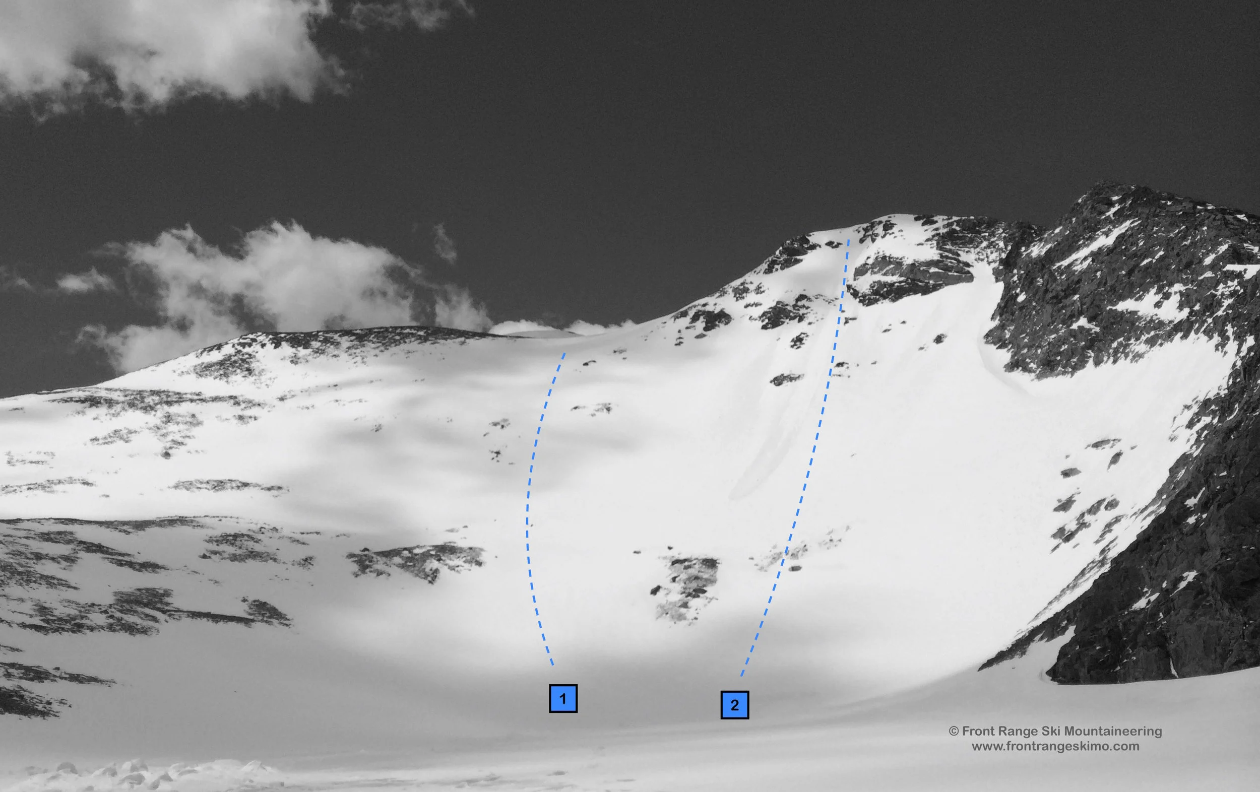
1 - Bancroft Bowl (East Bowl)
- Rating: II D5
- Season: Spring
- Exposure: East
- Vertical: 1,800'
- Approach Elevations: 10,400' - 13,250'
- Approach Distance: From Alice TH: 3.5 miles
- Top of Route Waypoint: 39.8372, -105.7005
The Bancroft Bowl is a great ski descent starting just north of the summit of Bancroft. The line quickly steepens after you leave the northeast ridge and if the snow is right this is a great place for wide open turns. In the height of the season, around mid-May, you can ski this from north of the summit to Lake Caroline, and then continue skiing northeast to Loch Lomond. There are several chutes to choose from just past the dam at Lake Caroline that drop to the Loch Lomond shore. From the top of the route to Loch Lomond is a 1,800' descent.
From the parking at Stewart Road in Alice, ski or hike west about a third of a mile on the jeep road to the first gate. This gate is closed June 1 to protect the wet road from erosion caused by high clearance vehicles. Continue about a mile and half past the second gate to Loch Lomond. Even in a big winter this jeep road can have stretches of dirt due to wind and sun. In June you could be hiking on dirt from the parking lot to near Loch Lomond. From the Loch Lomond climb up one of the chutes heading west and below the East Ridge into the basin holding Lake Caroline and below the easting facing Bancroft Bowl. Climb the bowl directly or take the more moderate southeast ridge to the summit.
2 – Sweet Caroline
- Rating: II D14 R3
- Season: Spring
- Exposure: Southeast
- Vertical: 1,000'
- Approach Elevations: 10,400' - 13,000'
- Approach Distance: From the Alice TH: 3.3 miles
- Top of Route Way Point: 39.8391, -105.6942
Sweet Caroline is the steep skier's left side of the Bancroft Bowl. This choice line starts at the top of Bancroft's East Ridge. The broad chute is laced with rocks and small cliffs, and there is a line clear of obstacles through the month of May. The top of the route is lined with a cornice, and this complicates the entrance. Consider Sweet Caroline as an alternative descent to the Bancroft Bowl!
Follow the approach that is described above for the Bancroft Bowl. Sweet Caroline is directly above Lake Caroline. Directly climb the Sweet Caroline face and chute so you know what you are getting into, or skip around it and up Bancroft Bowl to the top of the ridge.
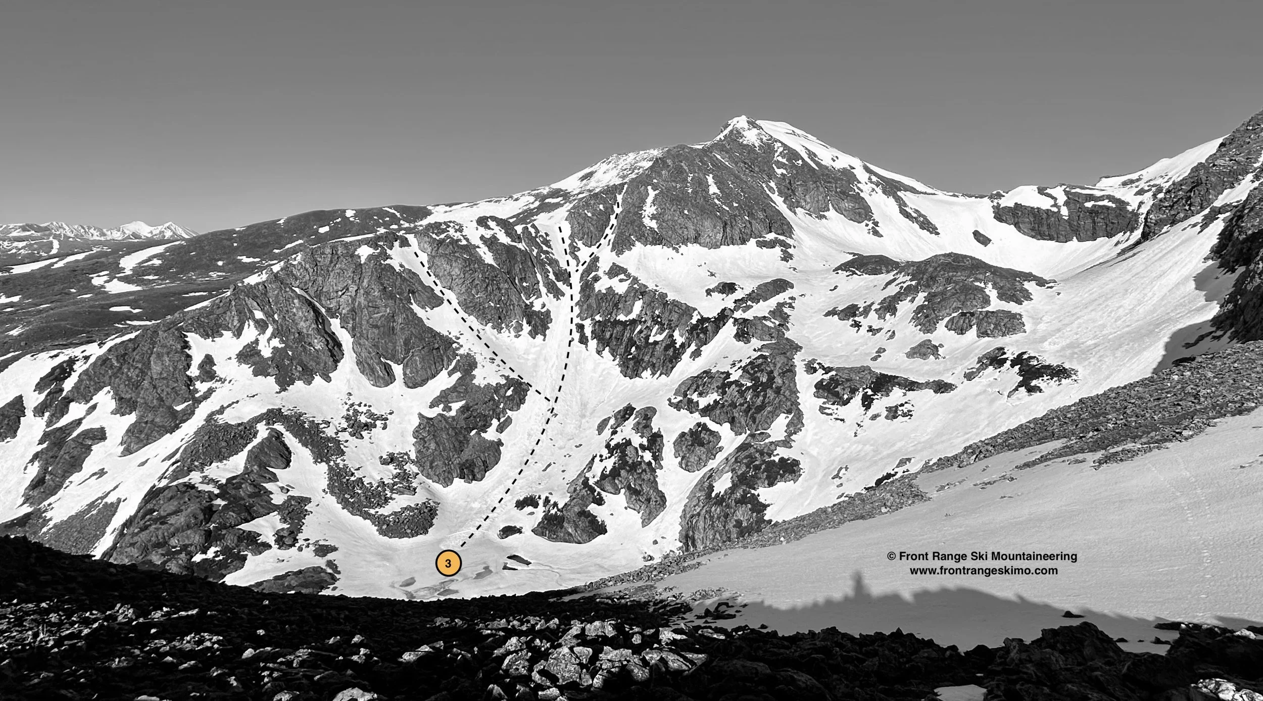
3 - Ohman Lake Couloirs
- Rating:II D12
- Average Angle, Steepest Angle: 36, 50
- ATES: Spring, Summer
- Aspect: Northeast, North
- Approach Elevations: 10,400' - 12.520'
- Approach Distance: From Alice TH: 3.6 miles
- Top of Route Waypoint: 39.83820, -105.68976
Mount Bancroft's north side holds deep and rocky basins filled with several glacial lakes. These cirques are surrounded by rocky outcroppings and ringed with couloirs. The terrain above Ohman Lake holds the most accessible couloirs in the basin. There are numerous lines above this lake, and the vertical ranges from 1,200' to 1,400'. Ice Lake Basin is nearly a thousand feet above Ohman Lake and holds additional lines. These may be better accessed from Mount Bancroft's summit.
+ TRAILHEAD
Alice (10,400')
This trailhead is in the Alice historic mining area. It is less of a trailhead and more of how far you can go on the road depending on the snow cover, the locked gates, and how tough and high your 4 wheel drive rig is. The Alice area is access from Exit 238 on Interstate 70. Take the Fall River Road northwest 8 miles to Alice Road. Turn left on Alice Road, continue where it converts to dirt, and reach Stewart Road in just under a mile. This may be as far as you can go early in the spring. If you park here, pull off of the road and avoid the no parking signs. Otherwise, bear right onto Stewart Road and continue about a third of a mile to the gate at the orange tailing pile. The gate here may open on June 1. If the gate is open and you have high clearance 4 wheel drive vehicle you can make it further up the road to the gate that opens around July 15.
+ MAPS & PICTURES
Below we have included a link to Front Range Skimo's master map. The routes on the map are approximations, and are not intended for use as a GPX track. To the right are a curated list of photos of the mountain.

Clicking on map above will open interactive Caltopo map website.