Bobtail Benchmark (12,802') and Friends
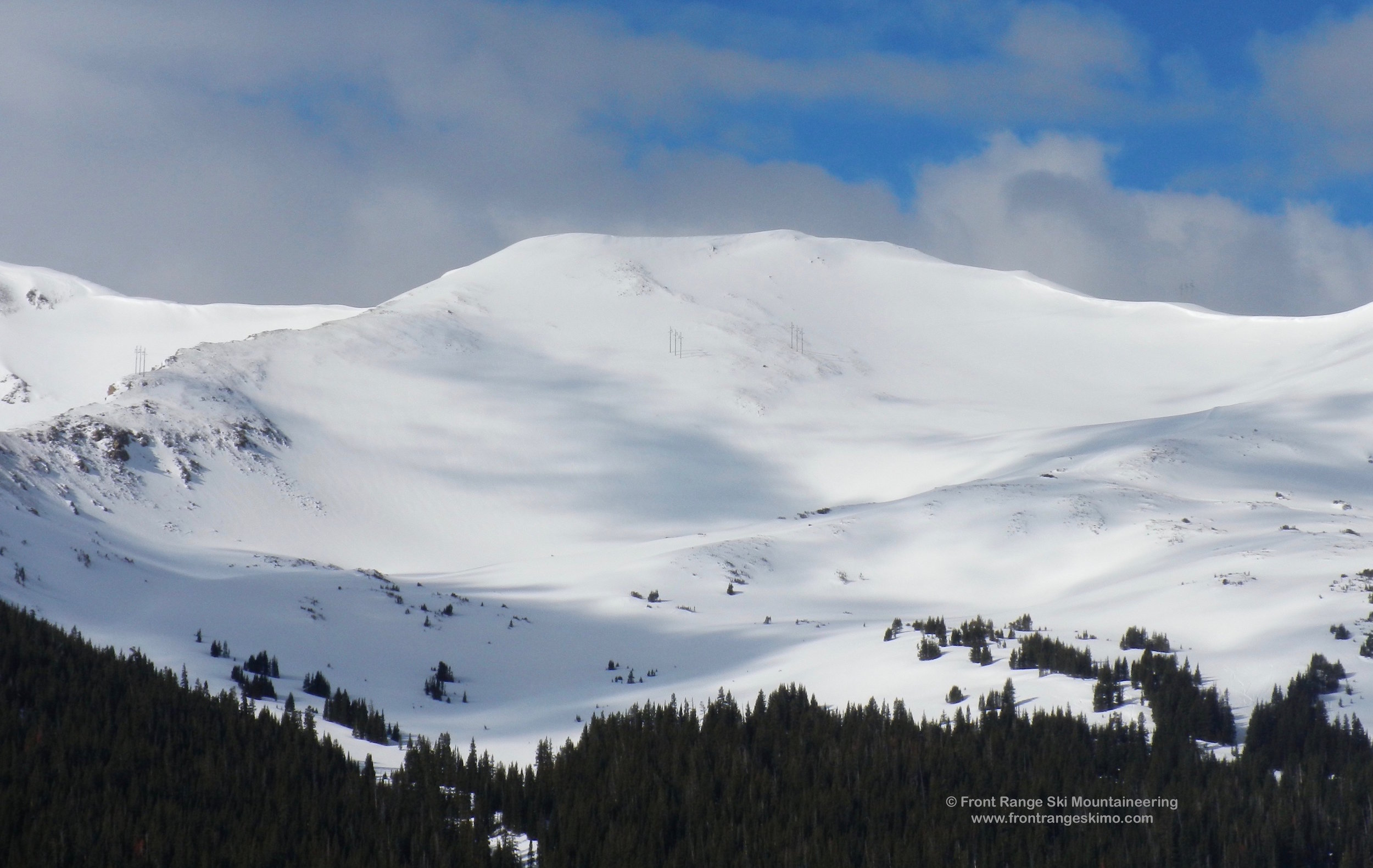
Bobtail Benchmark and Jones Pass are north. Photo: Rob Writz
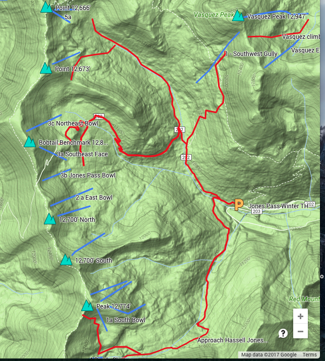
Bobtail Benchmark and Friends are a collection of 12,000 ‘ elevation peaks that are on the Continental Divide extending north from Hassell Peak to the Vasquez Peak Wilderness. These peaks flank the Butler Gulch, Jones Pass, and West Fork of Clear Creek valleys. Each peak is a standalone destination, and they also can be combined for a variety of excellent spring ski tours. The terrain that resides below these mountains is popular in the winter holding the Butler Gulch and Jones Pass Zones. Expect to see snowmobiles in the Jones Pass and West Fork Bowls.
The potential for high ski tours in this area is outstanding. The higher terrain of this region is best skied on a stable spring snowpack. Late March through May provides the opportunity for spring powder days and high tours.Once you are on the Continental Divide you can connect these peaks by staying high and traversing the ridge, or by skiing and climbing between the peaks. There are several low points that enable climbers to bypass the cornices that frequent the leeward side of the Divide. Get out your map, crack a beer, and get planning!
+ ROUTES
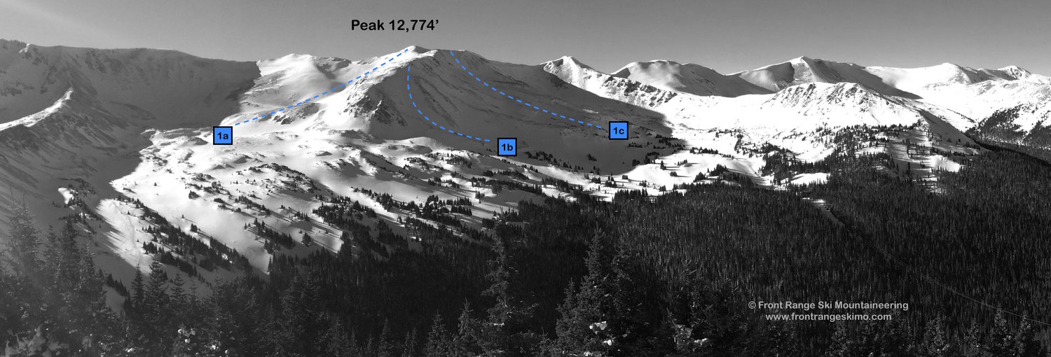
** 1 – Peak 12,774’
- Rating: II D4 – D6
- Season: Spring
- Exposure: South, East, North
- Vertical: 1,000’
- Approach Elevations: 10,465’ – 12,774’
- Approach Distance: From Jones Pass TH: 3.65 Miles
- Top of Route Waypoint: 39.7581, -105.8807
Peak 12,774’ is a gem of a mountain that is not as frequently skied as other peaks around Butler Gulch and Jones Pass. Like the other peaks in the area, the mountain sits on the Continental Divide. Unlike the other peaks, 12,774’ contains several aspects that receive good snow. The other peaks tend to have one aspect with snow and the remaining faces are often wind scoured. 12,774’ has the South Bowl (1a, D4), East Ridge (1b, D6), and North Bowl (1c, D6). All of these routes are best skied on stable spring snow.
If you use the approach described below, you get a good view of the South Bowl as you climb across its lower flank. This moderate route is the best way to descend the peak if you are not in the mood for the East Ridge or North Bowl. The East Ridge is the most interesting route on the peak. From the summit, descend along the ridge directly east, and the route turns northeast and provides a wide chute for the descent to Butler Gulch. There are also two surprise chutes near here that drop to the south. Finally, the North Bowl is a powder bowl skier’s dream. There are several options in this wide bowl and they all descend to the power line.
The skin track to Butler Gulch starts at the west end of the Jones Pass trailhead at the obvious Forest Service signs. Ski a hundred yards up the road to the split from Jones Pass road, and there is a sign showing Jones Pass to the right and Butler Gulch to the left.
Butler Gulch has a primary skin track that follows a ski trail up the center of the valley paralleling the creek. At approximately 1.45 miles, the skin track splits near the base of the Headwall Glades: go right and west to gain the low angle terrain below Peak 12,774’ [39.755, -105.861]
The path into this basin follows an old jeep road to tree line and winter’s Butler Bowl. This skin track frequently ends at 11,600' in Butler Bowl. Traverse northwest across low angle terrain to access the base of Peak 12,774’ at approximately 11,750’. Continue west across the gentle terrain, through the krumholtz trees, and weave around two small knolls. At 3.05 miles you are at a point where you are in the basin between Hassell Peak’s Divide Chutes on your left and Peak 12,774’ to your right. [39.7521, -105.8782] Climb towards Point 12,774’ and aim for a low point on the Divide that is west of the peak. This area has fewer cornices and can help you gain the ridge. Hike north on the Continental Divide to gain the gentle top of 12,744’.
After skiing the Chutes you can exit into Butler Gulch’s winter backcountry routes. If you ski the South Bowl you can exit the way you came in. The East Ridge and North Bowl routes leave you further to the north from the approach. An obvious landmark to help with the exit is the power line that rises from Butler Gulch and into the bowl between 12,774’ and the south Twin 12,700’ peak. You can follow this into Power Line and exit through dense trees to the Butler Gulch approach trail.
Shared Approach to Bobtail Benchmark and Twin 12,700’ Peaks
The path to these peaks starts at the west end of the Jones Pass trailhead at the obvious Forest Service signs. Ski a hundred yards up the road, and there is a sign showing Jones Pass to the right and Butler Gulch to the left.
Follow the Jones Pass Road into the Jones Pass Bowl. The path of the jeep road is obvious, especially after snowmobiles or a snow cat have gone ahead. The road climbs eight tenths of a mile to a clearing below Point 12,118. [39.7793, -105.8638] At this clearing the jeep road begins climbing and then switchbacks to the south across the base of Point 12,118 and then 1.25 miles to Jones Pass Bowl.
Additionally, there is a short cut that circumvents the Jones Pass Jeep road and goes into Jones Pass Bowl following the line of creek that drains the bowl. At approximately .65 miles on the ski in on Jones Pass Road, just past where the road turns to the north, there is an entry point west into the wood that follows the line of an old trail. [39.776944, -105.863889] There are several paths through this forest, but a common trail climbs west across the base of Point 12,118 then joins the creek to climb to Jones Pass Bowl near the road’s tree line switchbacks at approximately 11,500’ in elevation. From here you can go west across the basin to Bobtail Benchmark or south to the Twin 12,700’ Peaks.
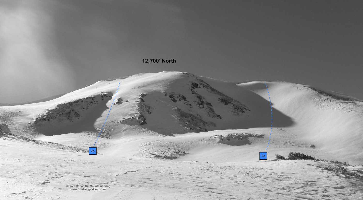
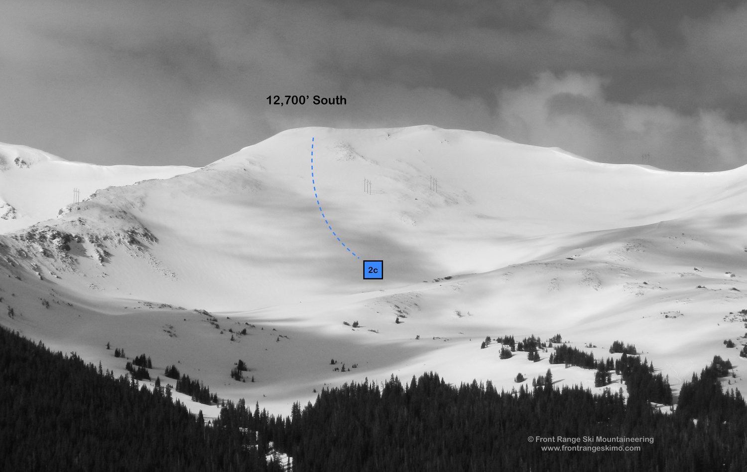
2 – Twin 12,700’ Peaks
- Rating: II D3 – D8
- Season: Spring
- Exposure: Northeast
- Vertical: 1,500’
- Approach Elevations: 10,465’ – 12,700’
- Approach Distance: From Jones Pass TH: 3.5 to 4 Miles
- Top of Route Waypoint: North Peak: 39.7692, -105.8871, South Peak: 39.7641, -105.8848
These two unnamed peaks stand next to each other and are both approximately 12,700’ in height. You can distinguish these from the other peaks on the Continental Divide by noting the power line that runs in the bowl between them. The power line is on the north side of Peak 12,700’ South. The north peak contains some of the area’s finer spring powder bowls at Jones Pass and is bordered by Jones Pass on the North.
The North Peak has the best lines and the most variety. The East Bowl (2a, D6) is the most prominent and aesthetic line, and the route drops in from the bump to the north of the peak. There are several chutes to the south of the East Bowl (2b, D8) that add more complexity to this mountain.
The power line that crosses the South Peak's northeast-facing slope is right in the middle of Power Line Bowl (2c, D3). This slope is wind scoured throughout the winter, but several substantial spring storms can cover the drop.
To access these peaks, follow the shared approach to 11,500’ on the Jones Pass Road to tree line. At this point you will be looking across the Jones Pass Bowl to the Twin Peaks. Traverse south across the bowl to the base of the peaks or continue to follow the Jones Pass Road. Climb the routes on frozen spring snow, or follow the road towards Jones Pass. The road disappears under the snow and enters steeper terrain that is challenging to traverse.
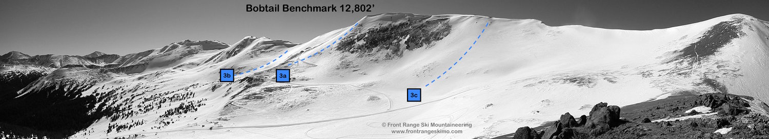
3 – Bobtail Benchmark
- Rating: II D4
- Season: Spring
- Exposure: East
- Vertical: 1,050’
- Approach Elevations: 10,465’ – 12,802’
- Approach Distance: From Jones Pass TH: 3.6 Miles
- Top of Route Waypoint: 39.7813, -105.8921
Bobtail Benchmark is the high point of the region above Jones Pass. The mountain’s northeast slopes are windswept all winter and even into the spring. The most reliable ski lines are the southeast and east facing slopes directly above the Jones Pass Road. The Southeast Face (3a, D4) dives directly into Jones Pass Bowl (3b,D4). The Northeast Bowl (3c, D6) holds some promise, and it is a popular spot for snowmobile high pointing. The skier’s right side of this bowl is wind scoured and thin even in the best winters. The skier’s left side holds the snow.
Follow the shared approach description to 11,500’ on the Jones Pass Road to tree line. At this point you will be looking across the Jones Pass Bowl at Bobtail Benchmark. Continue on Jones Pass Road. The Road turns to the southeast and several switchbacks navigate around several small and rocky knolls. The road continues across the southeast flanks of the mountain and may disappear under the snow, as you get closer to Jones Pass. Climb up to Jones Pass and be careful to navigate the cornices above you.
Shared Approach to 12,673’ and 12,666’
The path to the peaks surrounding West Fork Bowl starts at the west end of the Jones Pass trailhead at the obvious Forest Service signs. Ski a hundred yards up the road, and there is a sign showing Jones Pass to the right and Butler Gulch to the left.
Proceed to the right on Jones Pass Road. The road is obvious, especially after snowmobiles or a snow cat have gone ahead. The road climbs eight tenths of a mile to a clearing below Point 12,118. [39.7793, -105.8638] At this clearing break away from the Jones Pass Road and head north following a jeep road and the West Fork of Clear Creek. There is a well defined once Powder Addiction establishes the snow cat road. Continue into the West Fork Bowl, approximately 2.5 miles from the trailhead. [39.7948, -105.8833]
4 – 12,673’ Bowl
- Rating: II D5
- Season: Spring
- Exposure: East
- Vertical: 1,673’
- Approach Elevations: 10,465’ – 12,673’
- Approach Distance: From Jones Pass TH: 3 Miles
- Top of Route Waypoint: 39.789, -105.8874
The West Fork Bowl is bounded to the west by a ridge that curves from south to north. Point 12,673’ sits at the south end of this ridge. 12,673’ is also connected to Bobtail Benchmark further south. There are two primary routes down this peak. The most obvious is the East Face that looms above the approach. Just further north of the East Face is a nice looking corner shot. This line benefits from a northeast aspect and snow loading during the winter. You will want to wait until spring and a consolidated snowpack before descending the lines of 12,673’.
Follow the shared approach described above. You will be facing Point 12,666’ during the approach, but will catch glimpses up to 12,673’ to the left. When you are still in the valley, and between 11,400’ and 11,600’, start climbing to the southwest towards 12,673’. It is easy to skin up this terrain. You will zigzag through a series of knolls and up 600 vertical feet to flatter terrain below 12,673’. Head south to the saddle between 12,673’ and 12,118’ and then climb west to the summit.
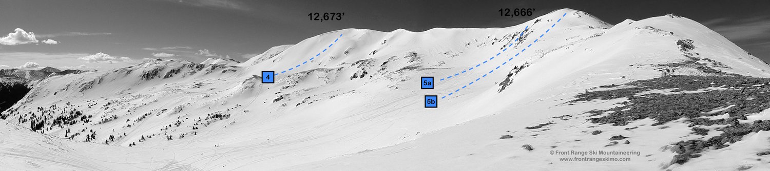
5 – Peak 12,666'
- Rating: II D6 – D9
- Season: Spring
- Exposure: Southeast
- Vertical: 1,666’3
- Approach Elevations: 10,465’ – 12,666’
- Approach Distance: From Jones Pass TH: 3.25 Miles
- Top of Route Waypoint: 39.7971, -105.8875
12,666’ is at the north end of the ridge above the West Fork of Clear Creek. This peak receives more wind influence than 12,673’ and the best skiing is in the spring after several sticky storms. It is not as windswept as Bobtail Peak, though! This peak is more complicated than 12,673’ as it holds several chutes on its southeast face. The two primary ski lines on this face are the Central Chute (5a, D9) and the broader East Flank (5b, D6) looker’s right of the Chute. The East Flank is a moderate alternative to Central Chute and is also part of the ascent. Both lines drop you down to the flat area at 12,120’. This point is often the top of the Powder Addictions Snowcat road.
Follow the directions in the shared approach described above. Point 12,666’ is staring right at you as you emerge from tree line. There are two options to climb the peak. If you have arrived early in the morning on frozen spring snow you can choose to follow the valley and snowcat road to the bench above the knoll at 12,120’ and then climb your route. Alternatively, you can continue to skin up the mountain by climbing north (right) from 11,800’ towards Vasquez Saddle. This low point is the divide between Clear Creek and Vasquez Creek. Follow the ridge to the west and up the edge of the East Flank to the summit.
+ TRAILHEAD
Jones Pass (10,465’)
Jones Pass and Butler Gulch share a winter trailhead. If you are coming from Interstate 70, leave the highway at Exit 232 for Winter Park and Highway 40. Drive slowly through the town of Empire as the town strictly enforces the 35 mph speed limit. From the Interstate 70 exit, drive 7.2 miles to the first major switchback on Berthoud Pass. Turn left on Henderson Mine Road to Jones Pass. Drive to the Henderson Mine complex and to your right is a small road leading 800 feet to the trailhead. [39.7712, -105.8548]
+ MAPS & PICTURES
Below we have included a link to a Google interactive map and a curated list of photos of the mountain.

Clicking on map above will open interactive Google map website