Clark Peak 12,951'
Clark Peak from the southeast. Photo: Rob Writz
Clark Peak is the highest point of the Medicine Bow Mountains. These majestic mountains extend 100 miles north from Cameron Pass in Colorado to Elk Mountain in Southern Wyoming. Clark Peak is named after William Clark, the Second Lieutenant of the 1804-06 Lewis and Clark Expedition chartered by Thomas Jefferson to discover and map the Louisiana Purchase and a route across the western half of North America. Clark Peak and Sawmill Creek are located in the southern reaches of Roosevelt National Forest’s Rawah Wilderness.
Clark Peak is a large mountain with numerous ski mountaineering possibilities. The west, east, and north sides contain massive bowls. The North Face descent from the summit looks like an interesting adventure deeper into the Medicine Bow Mountains. Clark Peak is most commonly climbed via the South Ridge, and ski mountaineers tend to descend part or all of Clark Bowl. This Bowl descends the south and east side of the mountain. The views from the summit include the Medicine Bow Mountains to the north and south, the Never Summer Mountains, and the west side of the Mummy Range in Rocky Mountain National Park.
+ ROUTES
1 - Clark Bowl
- Rating: III D6
- Season: Spring
- Exposure: South, Southeast
- Vertical: 2,350’
- Approach Elevations: 9,485’ – 12,951’
- Approach Distance: From Blue Lake Trailhead: 6.2 Miles
- Top of Route Waypoint: 40.6067, -105.93
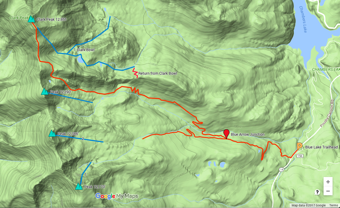
Clark Bowl is not steep, but it contains several large bowls stacked on top of each other. This leads to a long descent for Front Range standards. You can descend directly from the summit, but you will need to climb or skirt around the false summit to access the descent. The trick with Clark Bowl is determining what you want to do. Do you want to ski all of the bowls and into the Fall Creek basin, angle southeast and short cut back to the approach, or ski the top and then make your way back to Sawmill Creek? There are a lot of options on this peak, along with many chutes to explore into Fall Creek.
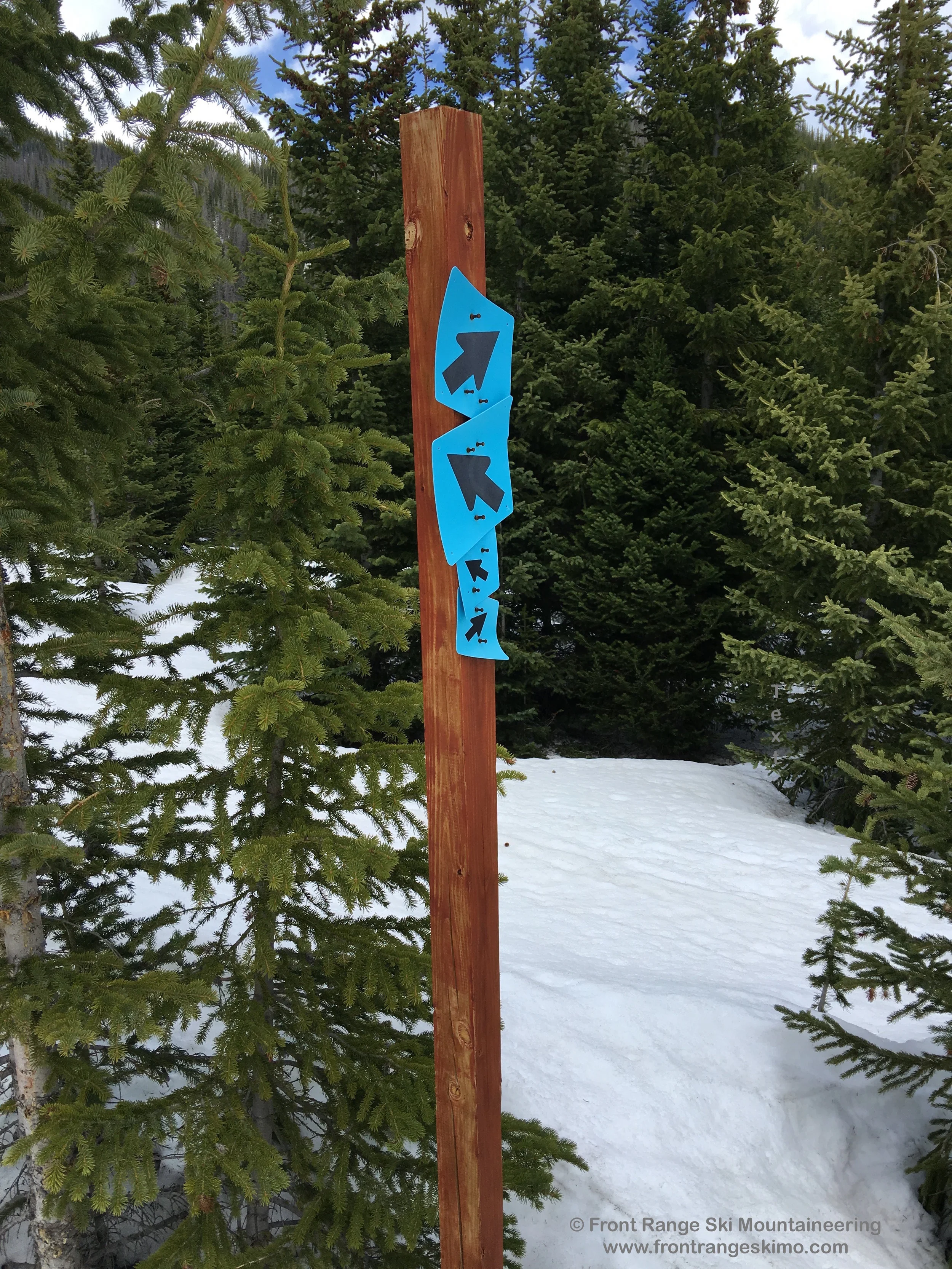
Park at the Blue Lake Trailhead on Highway 14 east of Cameron Pass. Walk about 0.2 miles west on the highway and cross Joe Wright Creek. On the right is a sign and gate for Sawmill Creek. Turn off the highway here and follow the Sawmill Creek trail. You will be following the blue diamonds of the Sawmill Creek trails for most of the ascent through the forest. The trail is an old logging road. At the first major turn to the left you can leave the road, ski straight uphill, and short cut a large switchback. If there is no snow, don’t take the short cut and stay on the road. Continue 1.7 miles to a fork in the road marked with 4 blue blazes and arrows. [40.5812, -105.8759]
Go right and descend to Sawmill Creek. Keep following the road and the blue blazes and arrows 1.5 miles through several switchbacks, bearing left at a major split, and then west to a dead end. [40.5896, -105.8945] During this part of the approach notice that you are now parallel with a ridge that runs west to east. This ridge divides Sawmill Creek from Fall Creek to the north. When you are at the two switchbacks described in the paragraph above you will be directly below a forested saddle on this ridge. This is the saddle described below for one of the return options. At the dead end continue west and below the ridge, climbing through a small and forested headwall along the creek. You will emerge above tree line on the north side of the basins below the northern Sawmill Creek Peak 12,390’. Continue west and then climb north to gain the break on the ridge between Sawmill Creek and Clark Peak. Traverse below Point 12,433' and you are then on the South Ridge. From here, hike up the South Ridge 0.9 miles to the summit.
The easiest way out is to retrace the approach back to the Sawmill Creek basin below 12,390'. If your timing and snow conditions permit, you may be able to climb and ski one or more of the Sawmill Peaks. There are two other options to exit. The longer option is to ski the entirety of Clark Bowl to the base in Fall Creek. This option gives you the full Clark Bowl ski descent: two big alpine bowls. The trick with the exit is to find the Blue Lake Trail and exit towards Chambers Lake and south to Blue Lake Trailhead. We have not done this exit, but it looks to be about 4 miles from where you find Blue Lake Trail to the trailhead. The second option is to ski the upper Clark Bowl to a lake at 11,520’. The ridge that we described in the approach is to your right. Skirt along the base of the ridge for an addition descent to 11,000’ and traverse right towards the forested saddle. Gain the saddle and descend to the approach from Sawmill Creek.
+ TRAILHEAD
Blue Lake Trailhead (9,485')
Blue Lake Trailhead is located approximately 63 miles west of the City of Fort Collins. The trailhead is a large paved parking lot on the north side of Colorado Highway 14. Long Draw Road is just across the street. The Sawmill Creek Trail is about 0.2 miles west on Highway 14 on the right.
+ MAPS & PICTURES
Below we have included a link to a Google interactive map and a curated list of photos of the mountain.

Clicking on map above will open interactive Google map website