Golden Bear 13,010'
Golden Bear from the East. Photo: Rob Writz
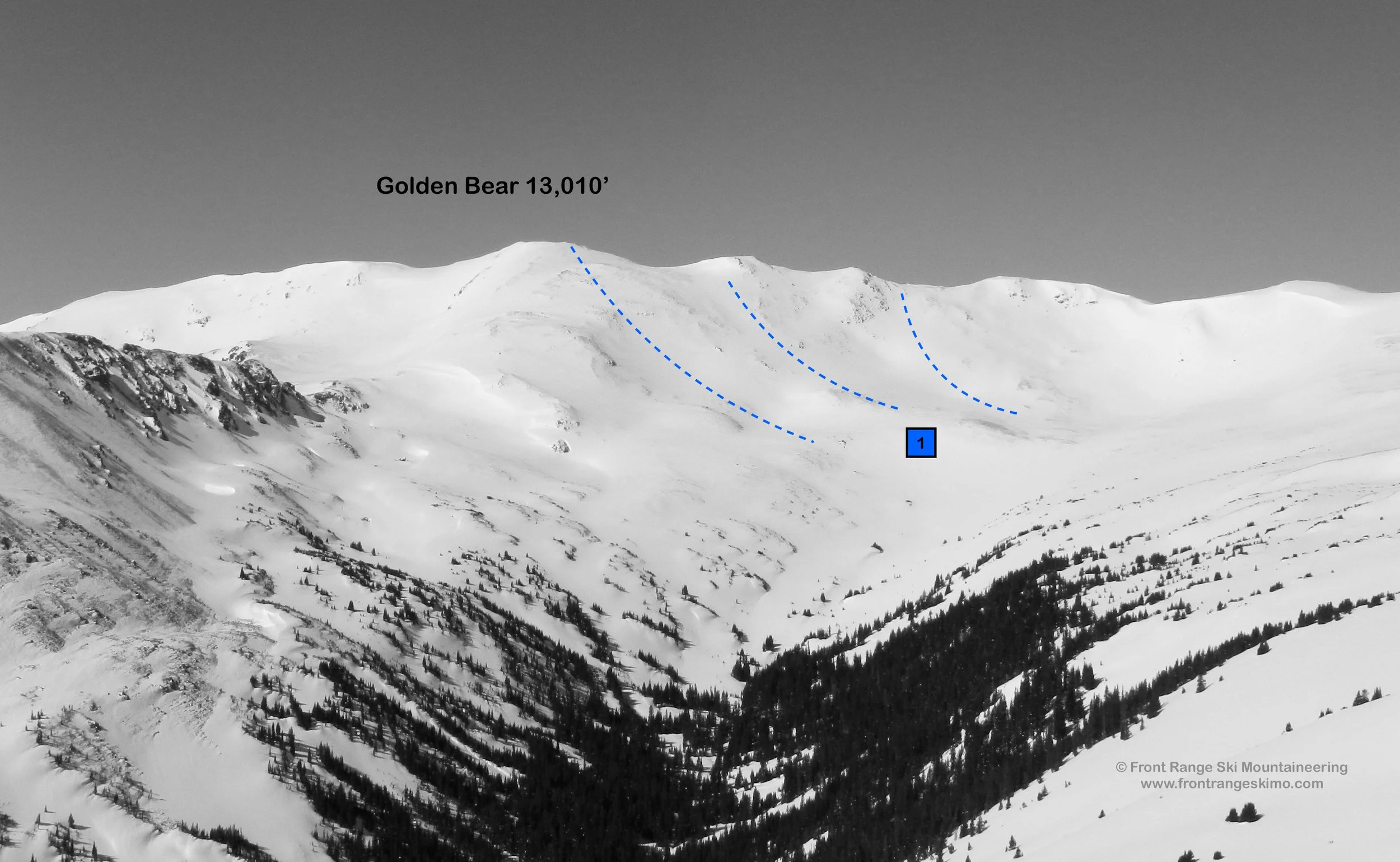
Golden Bear, or Thirteen Ten, is the highest point in the Loveland Ski Area. The summit is in Clear Creek County, Grand County, and Summit County. The east and south slopes of the peak are located within the ski area. The northeast bowls connecting Golden Bear to Hagar are outside of the ski area. The Northeast Bowl, described here, is accessed from Dry Gulch. A great day can be had combining a route on Hagar or Citadel with Golden Bear.
+ ROUTES
1 – Northeast Bowl
- Rating: II D3
- Season: Spring, Summer
- Exposure: Northeast, East
- Vertical: 1,500'
- Approach Elevations: 10,633' - 13,010'
- Approach Distance: From Dry Gulch TH: 3.8 miles
The Northeast Bowl of Golden Bear contains numerous descents with a lot of options depending on the snow cover. There are several smaller sub-peaks to the north on the Continental Divide that have open bowls similar to Golden Bear. There may be continuous snow to 11,500’. Choose your line from this summit or neighboring sub-peaks and remember this quote from Alex Lowe: “The best climber in the world is the one that has the most fun.”
From the gate at Dry Gulch, ski or hike up the Dry Gulch trail to the northeast. This will turn north and away from the interstate. The trail may quickly fade away if there is snow. Follow the line of the creek west through the valley staying on the right side of the creek to tree line. You will exit the forest and enter another forest on this approach. Climb northwest following the line of the creek drainage to 12,000’ below Hagar Mountain and Golden Bear. This is about 3.4 miles from the trailhead. From here turn south towards Golden Bear and climb the peak. One option is to climb to the saddle separating Golden Bear from Mount Trelease and climb Golden Bear’s East Ridge. The other option is to directly climb just over a third mile up the snowfields of the Northeast Face.
+ TRAILHEAD
Dry Gulch Trailhead (10,633’)
The Dry Gulch Trailhead is located at Exit 216 on Interstate 70. This exit is the same exit for Loveland Pass, the Loveland Ski Area, and the last exit before the Eisenhower-Johnson Tunnels. If you are exiting the interstate from the east the trailhead is immediately on your right. If there is a lot of snow you will park in a pull off to the right just before the off ramp goes under the interstate. If there is not snow you can continue northeast through this pull out on a dirt road to the gate at Dry Gulch. This is next to the eastbound lanes of the interstate, and there is no official Forest Service trailhead here. If you are coming from the west, exit the interstate, take a left on to Highway 6 and then an immediate left under the interstate. Look for the pull out described above on the left.
+ MAPS & PICTURES
Below we have included a link to a Google interactive map and a curated list of photos of the mountain.

Clicking on map above will open interactive Google map website