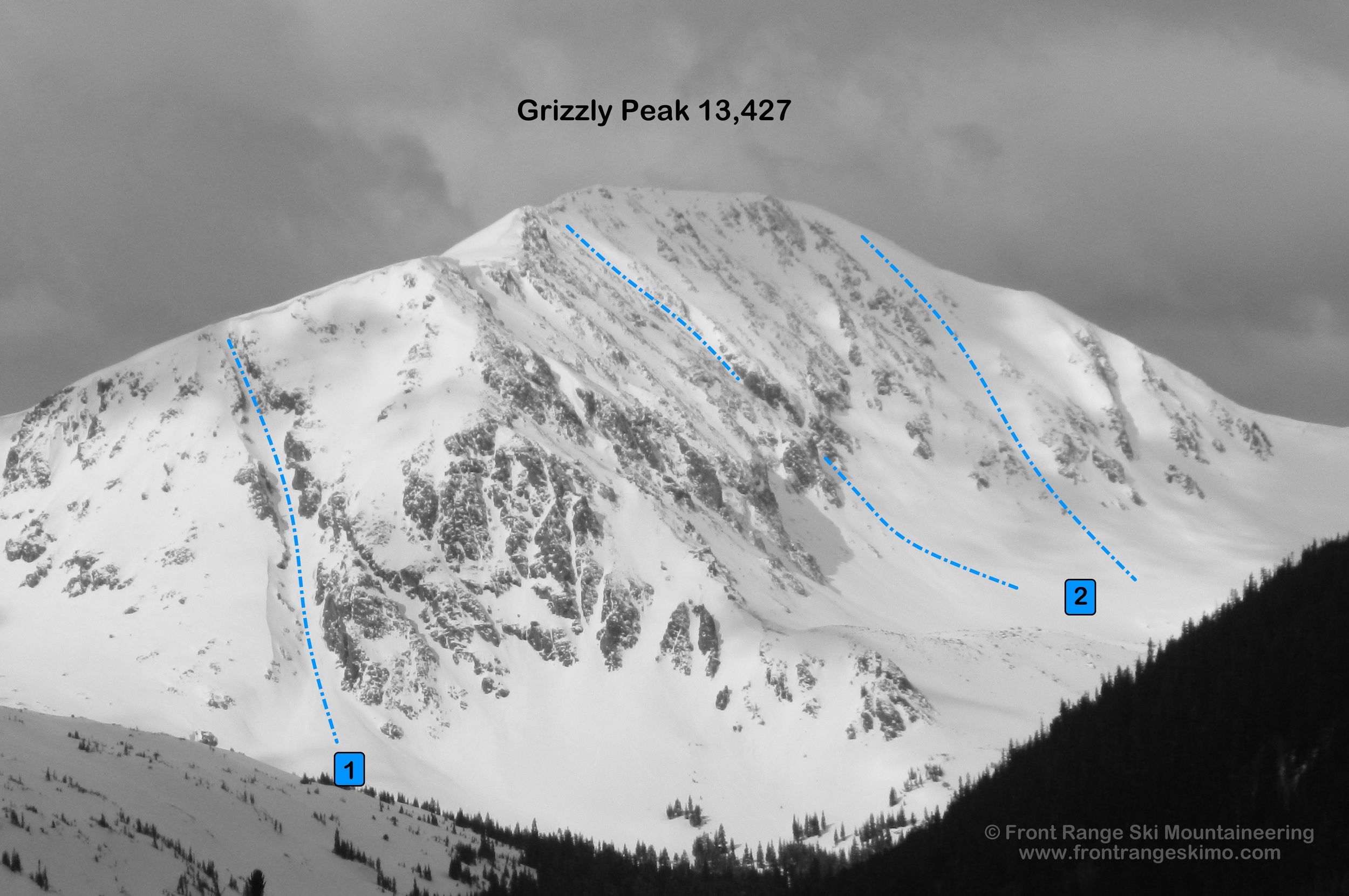
Grizzly Peak D 13,427'
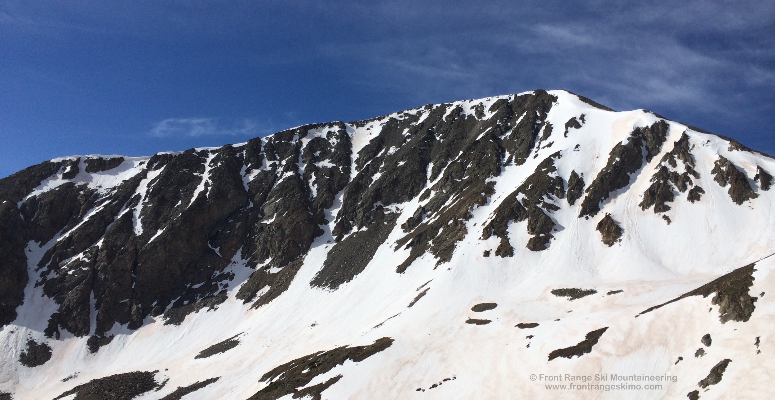
Grizzly Peak from the northeast. Photo: Rob Writz
Grizzly Peak is one of the great ski mountaineering peaks on the Front Range. Grizzly is cast in the same mold as its bigger brother to the east, Torreys Peak. Both peaks hold impressive routes on all aspects. The mountain is in an interesting geographic position in that it is highly accessible from the west, and more remote when approached from the east. The approach from Grizzly Gulch is a quiet experience in region that is becoming increasingly popular for ski mountaineering. The routes on Grizzly are high quality. The Grizzly Couloir goes head to head with any chute in competition for the title of “The Best Couloir” on the Front Range. The North Face holds numerous lines including Hourglass and the North Slope. There are several variations and options to ski on the bold North Face.
+ ROUTES
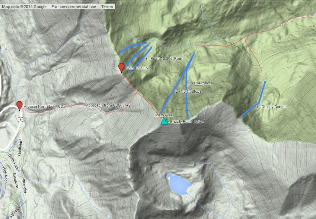
Route 1 - Grizzly Couloir
- Rating: II D15
- Season: Spring, Early Summer
- Exposure: Northeast
- Vertical: 800'
- Approach Elevations: 10,335' - 12,800'
- Approach Distance: From Grizzly Gulch TH: 3.2 miles
Grizzly Couloir is one of the classic chutes of the Front Range. It is bordered by rock walls, just wider than the length of a ski, and located in a remote part of the Interstate 70 corridor. The lower portion of the couloir is wider and not as steep, and the upper portion is steeper, narrower, and terminates at a massive overhanging cornice. This cornice will be on your mind the entire climb up the couloir. Most climbers who want to access the ridge will exit left to an exposed face that parallels the couloir and bypasses the cornice. This point is just below where the funnel from the wider couloir to the narrow, upper couloir. A ski descent of this bypass is steep, exposed, and committing!
The approach from the Grizzly Gulch trailhead follows road up the valley past Kelso Mountain and Torreys Peak. There are usually three open water stream crossings, with the first being the deepest and most challenging. The crossing is just up the road from the Grizzly Gulch Trailhead. Bring a pair of sandals for the crossing, dry off on the other side, put your boots on, and head up the trail. After the clearing below Torreys Peak’s Emperor Couloir the road is often snow covered and in the forest. You will have sporadic views of the Grizzly Couloir as you proceed up the valley. At around 11,400’ look for a way to the south side of the creek and hike or ski through an open basin to the couloir.

Grizzly Peak from the north. Photo: Rob Writz
Route 2 - North Face
- Rating: II D14, D11
- Season: Spring
- Exposure: North
- Vertical: 1,630'
- Approach Elevations: 11,080' - 13,427'
- Approach Distance: From A-Basin North Lot/CDOT: 1.2 miles, From Grizzly Gulch TH: 3.45 miles
The Hourglass (2a, D14) is a steep and aesthetic line that drops from the summit ridge that extends east from Grizzly’s summit. It catches the eye of ski mountaineers when they are at the summits of Cupid and Mount Sniktau. This is truly an hourglass shape as the upper and lower portions are broad, and the middle is about 25 feet wide. This route is a classic, and spicy enough to recommend climbing it before skiing it. Follow the approach to the Grizzly Couloir that is described above. At the point you cross south from the Grizzly Gulch Road to the Grizzly Couloir, continue west about a half mile through the trees and then to the basin below the Hourglass and North Slope. You have a good view from here to assess the conditions and the climb up the Hourglass. Another option is to access the Hourglass from the summit. To do this, walk east along the summit ridge about two tenths of a mile to elevation 13,200’. There may be a small cornice at the top.
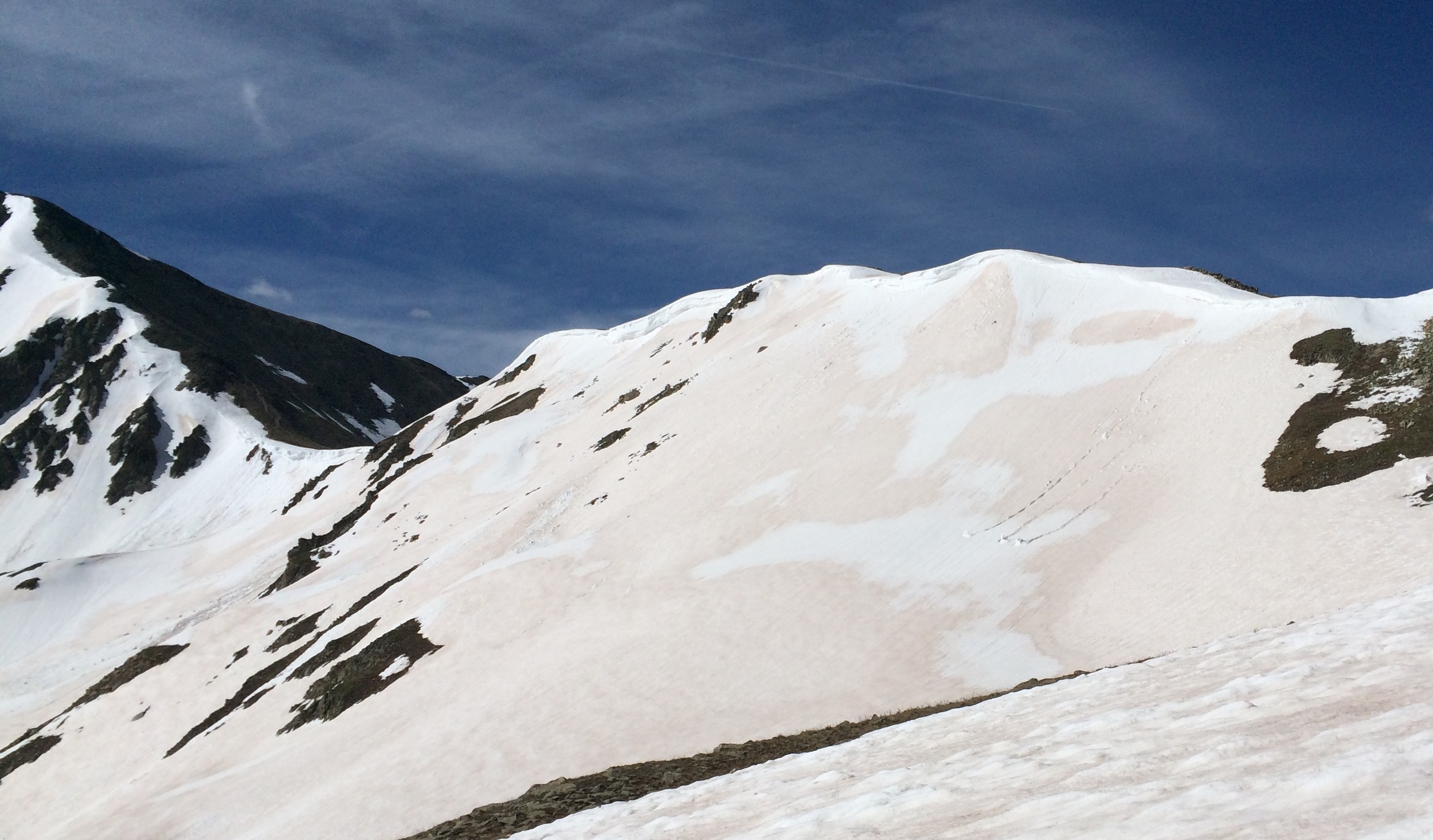
The North Slope (2b, D11) is a broad face on the edge of Grizzly Peak’s Northwest Ridge. There are several options to descend this route, and if you climb it first or approach via Cupid, you will be able to see the gullies at the bottom of the route. Like the other routes on Grizzly, this is a great ski descent! When these routes are in condition one of the biggest challenges is determining which route to ski. The route departs from the summit to the northwest and the steepest turns are where the ridge turns convex and points to the north. The North Slope is frequently approached from several points on Highway 6 to the west. Many ski mountaineers launch from Loveland Pass and climb Cupid en route to Grizzly Peak. Another west-side option is to follow the approach to the saddle between 12,936’ and Grizzly Peak that is described below. From this saddle, scramble a quarter mile up and southeast to Grizzly’s summit. When the North Face ski descent is done, skin to the saddle between Point 12,936’ and Cupid and ride Dave’s Wave back to Highway 6.
Route 3 - Point 12,936'
- Rating: II D4 - D6
- Season: Spring
- Exposure: Northeast
- Vertical: 740'
- Approach Elevations: 11,080' - 12,936'
- Approach Distance: From A-basin North Lot/ CDOT: 1.2 miles
The broad northeast facing bowl that extends from the summit of Point 12,936’ is a great combination with other routes in Grizzly Gulch. The northeast aspect will receive early sun, and will be thawed long before portions of Grizzly Peak’s Hourglass and North Slope. There are several different options for a descent of this face. A cornice lines the majority of the rim of the face, and the initial turns here are usually a drop in. The cornice is much larger to the south, and most skiers ride the more gentle slopes to the north. Combine this face with the Southeast Face of Cupid and an exit via Dave’s Wave for a day of moderate ski mountaineering in a fantastic setting.
From the North Lot at the Arapahoe Basin Ski area, go across Highway 6 and access the major gully north of the CDOT facility. This gully leads directly to the saddle between Grizzly Peak and Point 12,936’. Hike or skin alongside the gully to above tree line below Grizzly’s West Face and then break left to the saddle. It is just under one mile to the saddle from the trailhead, and then a quick romp from the saddle to Point 12,936’.
+ TRAILHEAD
Grizzly Gulch Trailhead (10,335’)
Grizzly Gulch Trailhead is accesses via Stevens Gulch Road. This is accessed from Exit 221 on Interstate 70. Drive south to a sharp left turn onto Road 321 (Stevens Gulch Road) towards Grays Peak. Earlier inthe spring, you may need to park here. Drive or ski one mile to the well signed right turn to Grizzly Gulch and Road 319. Follow this about a third of a mile to an open clearing and park here. If you have an off road rig and don’t mind the potential of getting stuck, you may be able to drive at least another mile up the rough road.
Arapahoe Basin North Lot (11,080’)
The far north parking lot at A-Basin is often used as a launching point for accessing routes on the west side of the Continental Divide and near Highway 6. Later in the spring there may be space at the big curve of Highway 6 just north of this parking lot and north of the CDOT facility.
+ MAPS & PICTURES
Below we have included a link to a Google interactive map and a curated list of photos of the mountain.
Clicking on map above will open interactive Google map website