Hagar Mountain 13,195'
Hagar Mountain from the south. Photo: Rob Writz
Hagar Mountain is a bold peak that draws the attention of skiers at the Loveland Ski Area all winter. From a distance this peak looks like an Alaskan mountain face. Well, make that a small Alaskan face. The steep pitch and the extensive snow loading on this face looks rugged and intimidating from afar. The routes are actually not that steep, and can be safely skied on compacted isothermal spring snow.
+ ROUTES
Shared Approach to 12,300'
The Southeast Face and the Boomerang Couloir share a common approach. From the gate at Dry Gulch, ski or hike up the Dry Gulch trail to the northeast. This will turn north and away from the interstate. The trail may quickly fade away. Follow the line of the creek west through the valley staying on the right side of the creek to tree line. You will exit the forest and enter another forest on this approach. Climb northwest following the line of the creek drainage to 12,000’ below Hagar Mountain and Golden Bear. From here turn north towards Hagar and climb a short but steeper push to a flatter spot at 12,300’, a total of about 3.5 miles from the trailhead at I-70 (before the gate).
Route 1 - Southeast Face
- Rating: II D6
- Season: Spring
- Exposure: Southeast
- Vertical: 1,200'
- Approach Elevations: 10,633' - 13,195'
- Approach Distance: From Dry Gulch TH: 4 miles
This is a spring classic ski descent. It is coveted by many Front Range ski mountaineers and for good reasons. The approach is direct and not complicated. The pitch is consistent, and the mountain is beautiful. Some skiers combine a trip to the Southeast Face of Hagar with a climb and ski of the Northeast Face of Golden Bear to the south. Get an early start as this southeast exposure receives an early sun hit. There are several options for descents of this broad face. Most skiers drop the gully between two summits. The upper portion has several steeper turns before the angle moderates. Pick your line and have fun. If there is a lot of snow the total ski descent vertical can be greater than what is noted here.
From 12,300’ aim for a saddle between the triangle-shaped south ridge of Hagar and a small sub-peak south of the summit. Scramble up the rocks on the left side of the blunt ridge or climb the snowfield to the summit itself. It is about another half mile from 12,300’ to the summit.
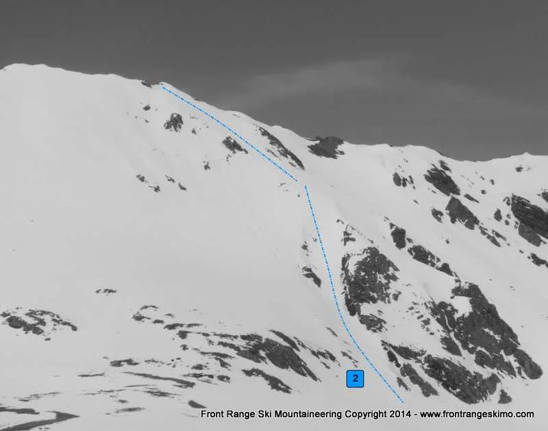
Route 2 - Boomerang Couloir
- Rating: II D8
- Season: Spring
- Exposure: South, Southeast
- Vertical: 1,000'
- Approach Elevations: 10,633' - 13,050'
- Approach Distance: From Dry Gulch TH: 4 miles
The Northeast Chute (Snoopy’s Backside) of The Citadel gets most of the couloir-grabbing attention in this part of the Front Range. The Boomerang Couloir of Hagar can easily compete with Snoopy’s for this honor. The Boomerang is located on the looker’s right side of the Southeast Face of Hagar. This beautiful line features a south-facing couloir that is lined with cliffs on both sides. The couloir takes a dogleg turn to the climber’s left into a wider and diamond shaped bowl northeast of Hagar’s summit. The lower portion of the couloir is shaded from the early sun, but the higher bowl is exposed to sunrise’s light. You should climb the couloir before you ski it to be safe.
From the bench at 12,300’ head north and angle towards the right side of Hagar’s southeast face. The bottom, south-facing portion of the Boomerang Couloir is tucked between a steep rock face and ridge on the right and rock slabs on the left.
+ TRAILHEAD
Dry Gulch Trailhead (10,633’)
The Dry Gulch Trailhead is located at Exit 216 on Interstate 70. This exit is the same exit for Loveland Pass, the Loveland Ski Area, and it is the last exit before the Eisenhower-Johnson Tunnels. If you are exiting the interstate from the east the trailhead is immediately on your right. If there is a lot of snow you will park in a pull off to the right just before the off ramp goes under the interstate. If there is not snow you can continue northeast through this pull out on a dirt road to the gate at Dry Gulch. This is next to the eastbound lanes of the interstate, and there is no official Forest Service trailhead here. If you are coming from the west, exit the interstate, take a left on to Highway 6 and then an immediate left under the interstate. Look for the pull out described above on the left.
+ MAPS & PICTURES
Below we have included a link to a Google interactive map and a curated list of photos of the mountain.

Clicking on map above will open interactive Google map website