Hassell Peak 13,215'
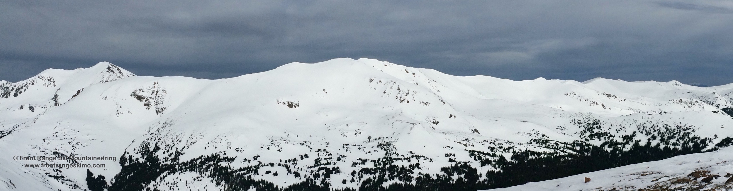
Hassell Peak from the Southeast. Photo: Rob Writz
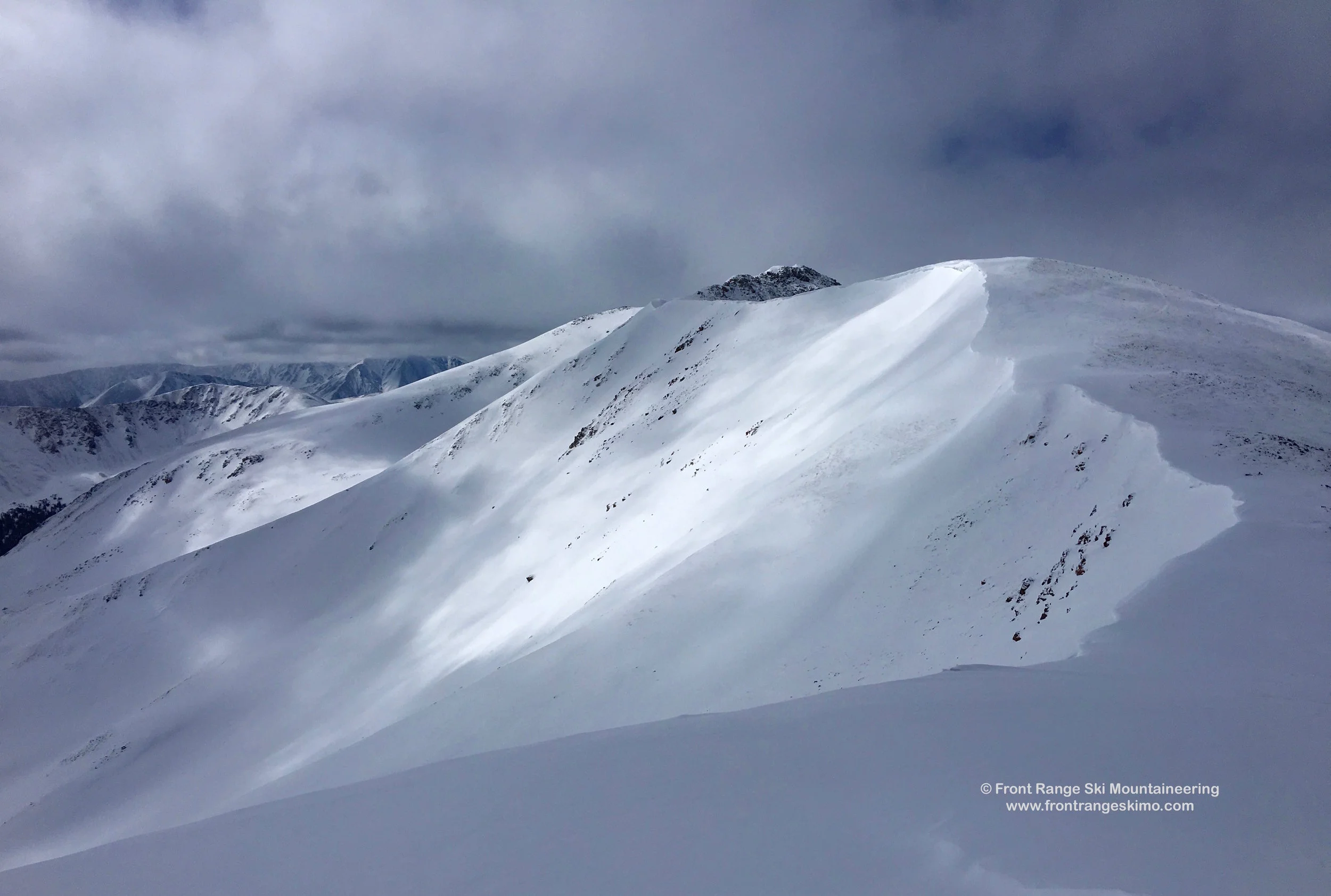
Hassell Peak is a big mountain that occupies a large portion of the Continental Divide between Woods Creek on the east and Bobtail Creek to the west. The 13,215’ summit of Hassell Peak is the high point of a long ridge running from Jones Pass to Herman Gulch. The mountain is not particularly steep and this allows for many options including high tours of the area. The east side of the mountain has numerous bowls to chose from and each has considerable vertical drops. A high tour along the Continental Divide that combines Hassell Peak with Bobtail Benchmark and Friends is a great high skimo outing. There are many snowfields on this ridge and many options for a loop tour originating from the Jones Pass Winter Trailhead.
+ ROUTES
1 – Southeast Bowl
- Rating: II D6
- Season: Spring
- Exposure: Southeast
- Vertical: 1,800’
- Approach Elevations: 10,255’ – 13,215’
- Approach Distance: From Herman Gulch TH: 4.65 Miles
- Top of Route Waypoint: 39.7422, -105.8824
The Southeast Bowl is an expansive face that starts with a mellow grade and then rolls into a steeper mid-30 degree pitch to tree line. There are many ways to ski this bowl and there is even more terrain to discover to the south along the ridge. The south-facing slopes are wide and drop to Woods Creek.
We recommend using the Herman Gulch Trailhead to access the Southeast Bowl. From the Herman Gulch Trailhead find the start of the trail on the north side of the parking lot. Follow the trail east for a few minutes to a fork where the Watrous Gulch Trail continues east and Herman Gulch goes west. Take the Herman Gulch trail. The trail reaches a flat terrain at 10,750’. If there is enough snow for skinning you can deviate from the trail and follow the line of the creek up the wide and flat valley about 2.5 miles to 11,400’. [39.72, -105.8826]. Climb north through the forest to 12,000' on the ridge separating Herman Gulch and Woods Creek (about 3 miles from the trailhead). At this point you will have a view of the South Slopes and the Southeast Bowl. There are two options to climb Hassell Peak from here. First, you can turn west and climb north to the high slopes leading to Hassell Peak. This is about 1.5 miles from the ridge. Second, you can descend into the Woods Creek basin and then climb the South Slopes. This is about 1.4 miles from the ridge.
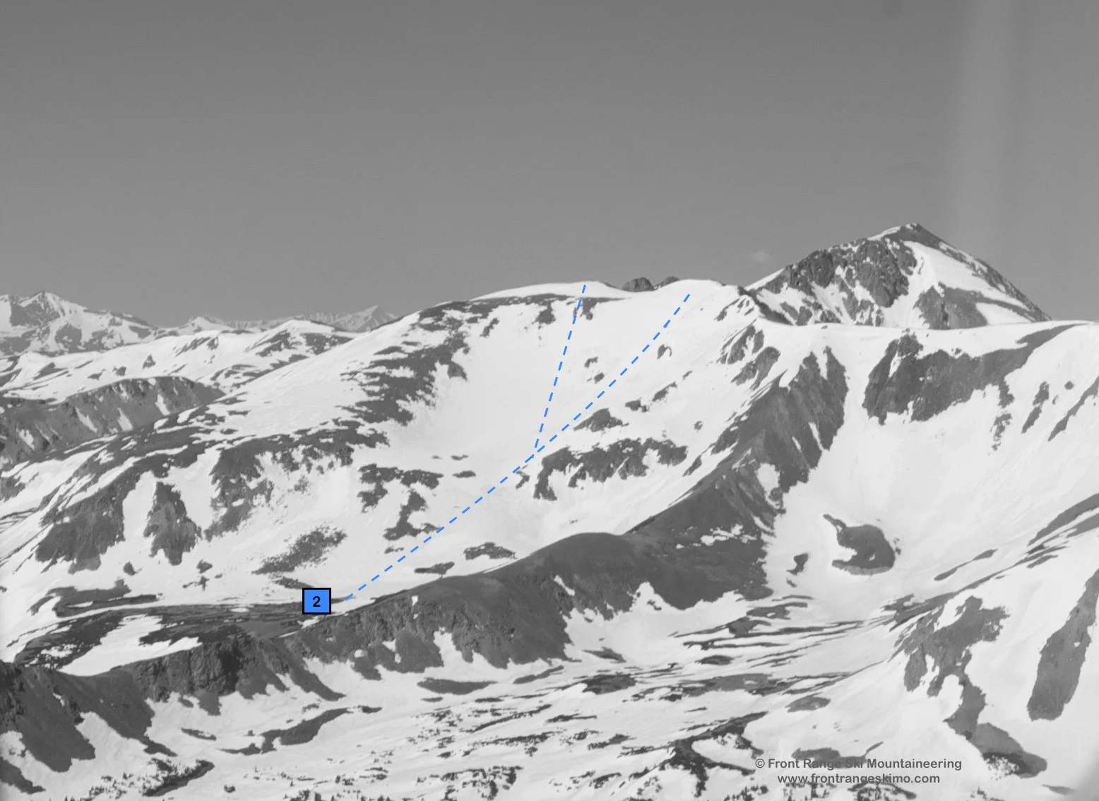
2 – Northeast Lake Bowl
- Rating: II D6
- Season: Spring
- Exposure: Northeast
- Vertical: 2,000’
- Approach Elevations: 10,465’ – 13,215’
- Approach Distance: From Jones Pass TH: 3.5 Miles
- Top of Route Waypoint: 39.7422, -105.8824
The Northeast Lake Bowl is a tad bit steeper in pitch than the Southeast Bowl. Like the Southeast Bowl you can usually begin the descent from the summit. Another option is to continue north on the ridge from the summit to the 13,200’ north peak of Hassell and drop in from here. This point allows for a steeper, but corniced entrance into the bowl.
The Northeast Lake Bowl can be climbed via the same route as the Southeast Bowl. A shorter alternative to this is launching from the Jones Pass Winter Trailhead and climbing up Butler Gulch. Go west from the winter trailhead past the Forest Service signs. About a hundred yards up the road there is a split from Jones Pass road, and there is a sign indicating Butler Gulch to the left. Follow the obvious track up the gulch and to tree line. Go west in the large Butler Gulch basin and follow the east-west trending ridge that separates this basin from the Woods Creek basin. There is a point in the ridge when the angle rises steeply to Hassell Peak. [39.7487, -105.8764] Climb south over this saddle to arrive at the base of the Northeast Bowl.
You can return via Butler Gulch. Ski the Northeast Bowl, and down two basins to Hassell Lake. [39.7446, -105.8614]. Go east two tenths of a mile and find the jeep road that switchbacks north to the saddle above Butler Gulch.
3 - Woods Creek Couloir
- Rating: II D14
- Season: Spring
- Exposure: East
- Vertical: 800'
- Approach Elevations: 10,300' - 12,865'
- Approach Distance: From Herman Gulch Trailhead: 3.5 Miles
- Base of Route Waypoint: 39.7309, -105.8841
This couloir sits at the head of Woods Creek at the south end of Hassell Peak's South Ridge. The couloir is relatively short but it is a complex line and worthy of a trip to ski or snowboard just this line. The chute is steeper than it looks, and there is a double fall line in the lower half of the line. There are small cliffs in this chute in the summer, and these eventually get covered in snow. These small cliffs are near vertical drops in the upper portion of the chute. You will want to climb this couloir before you ski it.
Follow the approach described above for the Southeast Face. From the ridge between Herman Gulch and Woods Creek you can skin north to get a side perspective edge of the couloir. Descend into the bowl and to the base of the chute.
4 – Divide Chutes
- Rating: II D7 – D13
- Season: Spring
- Exposure: East
- Vertical: 1,000’
- Approach Elevations: 10,465’ – 13,020’
- Approach Distance: From Jones Pass TH: 4.15 Miles
- Top of Route Waypoint: 39.749, -105.8844
The Divide Chutes reside, as the name implies, on the Continental Divide. This is on the ridge extending north from Hassell Peak towards Peak 12,774’ and Jones Pass. There are several lines to choose from and the chutes on skier’s right are the steepest. Cornices persist at the top of the Chutes all winter. The terrain surrounding the Divide Chutes and Butler Gulch is a Grade A spring skiing arena. These high quality chutes are best skied in the spring when the snowpack is consolidated. One of our favorite zones for a late April or early May powder day on stable snow is this bowl.
The Divide Chutes are above the Butler Gulch winter backcountry zone and the approach is the same for Butler Bowl. Start at the west end of the Jones Pass winter trailhead at the obvious Forest Service signs. Ski a hundred yards up the road to the split from Jones Pass road, and there is a sign showing Jones Pass to the right and Butler Gulch to the left.
Butler Gulch has a primary skin track that follows a ski trail up the center of the valley paralleling the creek. Follow this trail to the point where it switchbacks up and into the Headwall Glades. At approximately 1.45 miles, the skin track splits and you will go west (right) towards the top of Creek Chute (AKA Halfpipe Gully).
This skin track frequently ends at 11,600' in Butler Bowl and above Creek Chute. Continue west across the gentle terrain, through the krumholtz trees, and weave around two small knolls. At 3.05 miles you are at a point where you are in the basin between the Divide Chutes on your left and Point 12,774’ to your right. [39.7521, -105.8782] If it is late spring and the snowpack is fully isothermic than you may consider climbing the Divide Chutes. Otherwise, skin towards Point 12,774’ and aim for a low point on the Divide that is west of the peak. This area has fewer cornices and can help you gain the ridge. Hike south on the Continental Divide to gain the top of the chutes.
After skiing the Chutes you can exit into Creek Chute or the surrounding bowl. The Butler Gulch routes all lead to the creek. You may need to climb out of the creek and uphill to reach the skin track that climbs the middle of Butler Gulch.
+ TRAILHEAD
Herman Gulch Trailhead (10,300’)
Herman Gulch Trailhead is located on exit 218 on Interstate 70. This is west of Bakersville and east of Loveland Pass. There is a massive parking lot on the north side of the exit with an information kiosk and outhouses. The Herman Gulch trail starts next to the kiosk by the outhouses. [39.7024, -105.8545]
Jones Pass Winter Trailhead (10,465’)
The Jones Pass Trailhead is used to access Butler Gulch and the Northeast Bowl of Hassell Peak. If you are coming from Interstate 70, leave the highway at Exit 232 for Winter Park and Highway 40. Drive slowly through the town of Empire as the town strictly enforces the 35 mph speed limit. From the Interstate 70 exit, drive 7.2 miles to the first major switchback on Berthoud Pass. Turn left on Henderson Mine Road to Jones Pass. Drive to the Henderson Mine complex and to your right is a small road leading 800 feet to the winter trailhead. [39.7712, -105.8548] If there has been significant snow, this small road may not be plowed and not passable. To the left is a large lot that you can park in. This lot is commonly used by snowmobiles. The Jones Pass and Butler Gulch winter trailhead serves both motorized and non-motorized winter users. Most trucks and trailers park at the lower lot near the mine, or in the first of the upper two lots.
+ MAPS & PICTURES
Below we have included a link to a Google interactive map and a curated list of photos of the mountain.

Clicking on map above will open interactive Google map website