Howard Mountain 12,810'
Howard Mountain from the Southeast. Photo: Rob Writz
Howard Mountain is the second highest peak in the Never Summer Mountains. The terrain surrounding the mountain provides skiers and snowboarders days worth of riding potential. The large ridge extending east from the summit to above the Grand Ditch has numerous chutes on the north and south side. The rocky Point 12, 253’ above Peacock Pool has several chutes to explore as well. The two high sub-peaks to the south of Howard Mountain towards Mount Cumulus has several broad snowfields that welcome skiers with open arms as they approach via the south basin. The large peak immediately to the south of Howard Mountain can easily confuse climbers and be mistaken for the summit.
+ ROUTES
1 - South Face
- Rating: III D8
- Season: Spring
- Exposure: Southeast, South
- Vertical: 2,530’
- Approach Elevations: 9,005’ – 12,810’
- Approach Distance: From Colorado River Trailhead: 4.85 Miles
- Base of Route Waypoint: 40.4237, -105.8922
The South Face is a straight-forward descent. There is a small cornice at the top that can be dodged on the skier's left, and cliffs to avoid on the right side of the descent. Enjoy the initially steep turns and then crank out big ones in the basin below. As the heat and sun intensity of late spring increases, the direct line up the South Face begins to melt out. This line, along with the routes on the other peaks accessed via the Grand Ditch, is best skied from late April to late May. During this window you have a higher chance of skiing to and from the trailhead.
Find the trailhead signs at the north end of the Colorado River Trailhead parking lot. Follow the trail north 0.4 miles to a junction with a sign showing the Poudre Pass Trail and Red Mountain Trail junction. Go left to follow the Red Mountain Trail. This trail will quickly cross the Colorado River on a bridge and then into a clearing. If it is light at this time you can look up and see the slide path on Red Mountain. You will want to aim for this during your approach.
Cross the clearing and follow the trail southwest and then south to cross Opposition Creek. If you are approaching in June this should be clear of snow. In April or early May there are hopefully snowshoe and ski tracks guiding you to a small bridge crossing the creek. It is tempting to go straight up Opposition Creek and Hells Hip Pocket. This gorge is very steep and difficult to ascend and descend.
Continue a climbing traverse on the trail 0.25 miles past the Opposition Creek crossing and small bridge. If you are on the trail in the summer then continue to follow it miles to the Grand Ditch (3.2 miles from the Poudre Pass Trail junction). If you are here earlier and there is snow cover, look to break off the trail at approximately 9,300’ and 0.25 miles past the Opposition Creek crossing’s small bridge. Look for a more open area in the aspens and rocks and skin uphill to the west. It is hard to follow the trail in snow above this elevation anyway. Climb west up a mellow slope and then up one steep slope. Head north on flatter terrain to Opposition Creek. Turn west and follow Opposition Creek to the intersection with the Grand Ditch at 10,240’. Alternatively, you can continue straight uphill from 9,300’ to intersect the Grand Ditch below Red Mountain.
When you access the Grand Ditch, your next objective is to find Mosquito Creek. Go north 0.45 miles on the Grand Ditch from Opposition Creek to where the ditch turns hard right and to the east. At this point there are two poles standing next to each other. This signals the entrance to Mosquito Creek. Cross the ditch and then follow the creek up the gentle hill and through the moss covered forget. Make your way to the right side of the creek. In 0.2 miles you will reach a small gorge and you can climb around on either side. After you pass the gorge there is a large clearing on the east side of the creek. Continue across this clearing, then into the forest, and traverse north below the large rock buttress. The north end of this rock buttress has a slope to climb that leads to Peacock Pool. From Peacock Pool, climb east on gentle terrain 0.65 miles to the bottom of the South Face. Climb the right side of the South Face to the sent. The left side leads into a class 3 ridge.
+ TRAILHEAD
Colorado River Trailhead (9,005’)
The Colorado River Trailhead is 9.9 miles north of Rocky Mountain National Park’s Grand Lake Entrance and Kawuneeche Visitor Center on Highway 34 (Trail Ridge Road). There is a daily fee for entering the park. The Kawuneeche entrance is 1.5 miles north of the town of Grand Lake. [40.4018, -105.8488]
If you are here before June then you will see the road closure when you arrive at the trailhead. There is a road to the left that drops down to the Colorado River Trailhead. The trailhead has ample parking and bathrooms.
+ MAPS & PICTURES
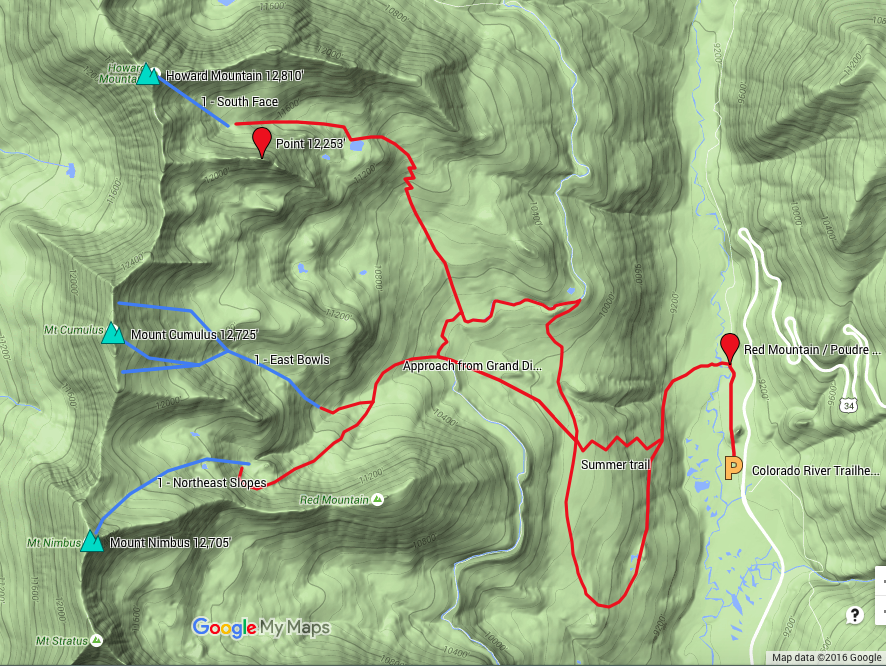
Below we have included a link to a Google interactive map and a curated list of photos of the mountain.

Clicking on map above will open interactive Google map website