Jasper Peak, 12,923'
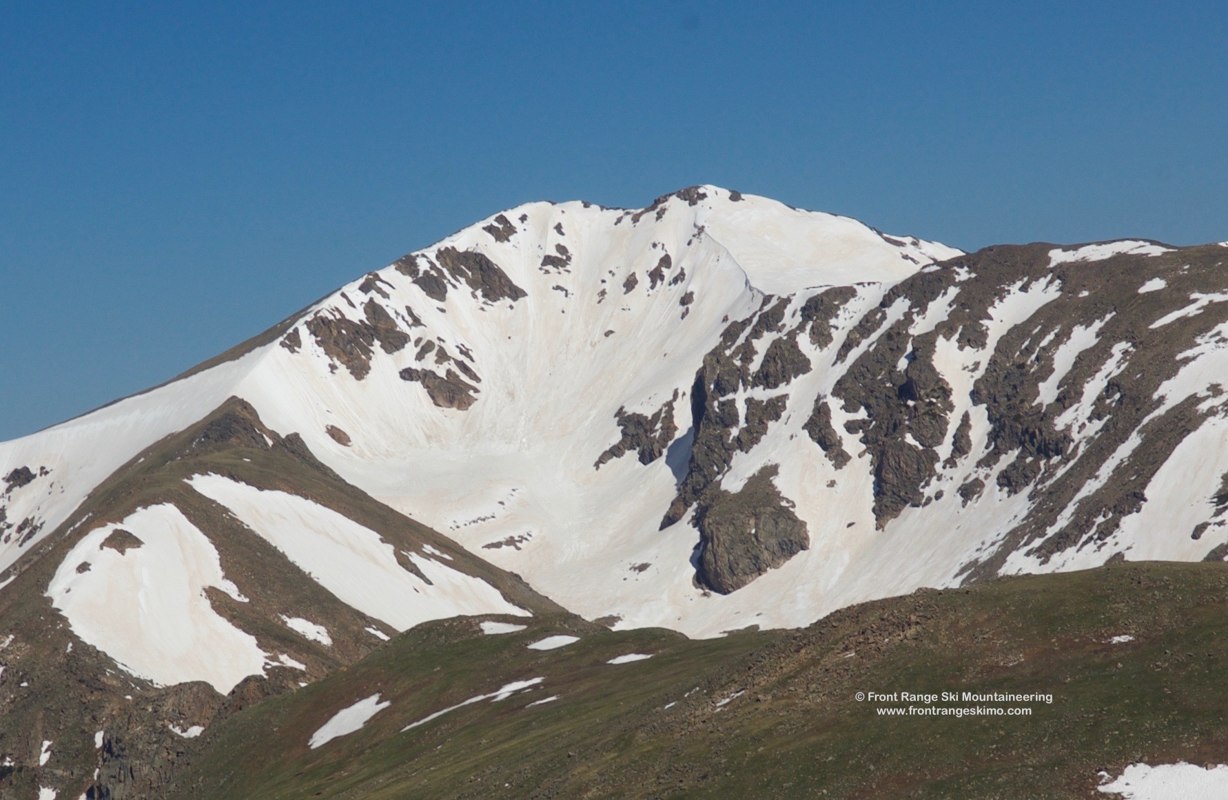
Jasper Peak from the North. Photo: Rob Writz
Jasper Peak is the commonly used name for Peak 12,293’. This fantastic mountain sits at the headwaters of Boulder Creek, and it has ski mountaineering routes on several sides. Jasper Peak seems to pull in more snow than other mountains in the Indian Peaks, and this is seen on the Northeast Slopes and the Snow Lion, the two leeward slopes of the mountain. A good place to preview this peak from is the intersection of Highway 128 and McCaslin Boulevard in Superior.
+ ROUTES
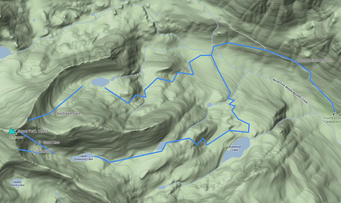
Shared Approach to Middle Boulder Creek:
From the Fourth of July Trailhead, follow the Arapahoe Pass Trail just over 1 mile to a fork where the Arapahoe Pass Trail continues up and west and the Diamond Lake Trail goes down and southwest. Follow the Diamond Lake Trail just over a third of a mile to Middle Boulder Creek. If the trail is snow covered, the hiking bridge over the creek is a good landmark.
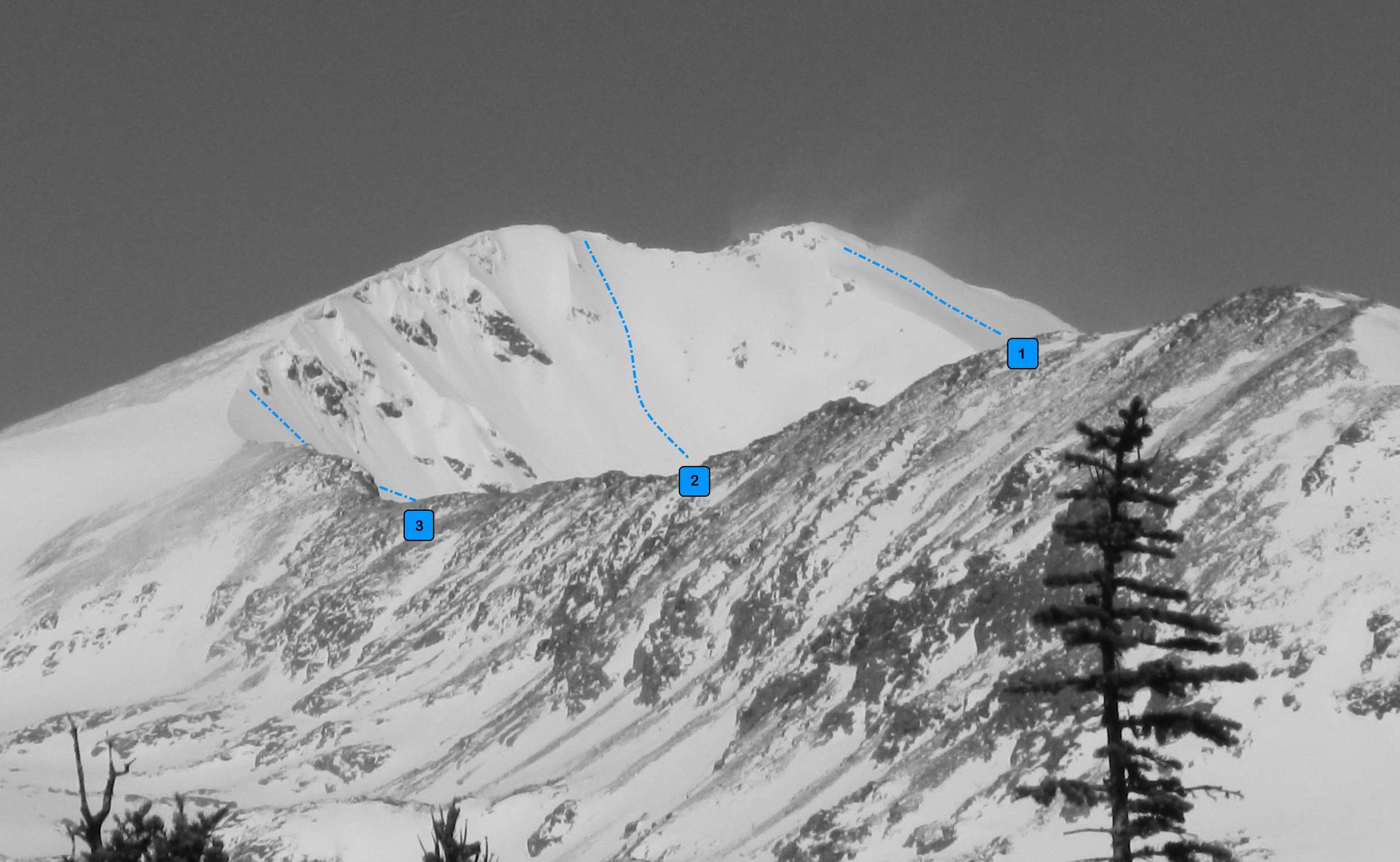
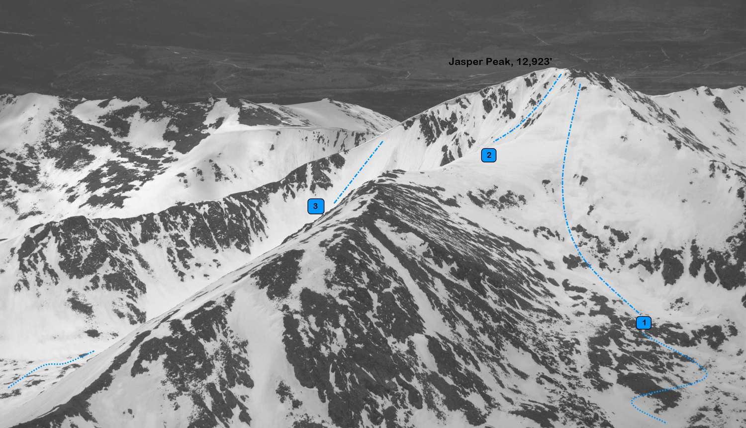
Route 1 - Northeast Face
- Rating: II D5
- Season: Spring, Summer
- Exposure: Northeast
- Vertical: 1,200’
- Approach Elevations: 10,120’ – 12,800’
- Approach Distance: From 4th of July TH: 3 miles
The Northeast Slopes of Jasper are sometimes used as an approach to Snow Lion. This face is a great ski descent in its own right and more moderate than Snow Lion. The snow loads onto this face all winter, and the top of the face feels like a summit. There can be a 1,200' ski line to the lake at 11,575' and more below that.
While you are approaching on the Arapaho Pass Trail you get a good look at this face. You also get a good look at the steep sub peak 12,047' at the end of Jasper's Northeast Ridge. Your goal during this approach is to be south of that sub peak and reach the lake at 11,575'. From the intersection of the Diamond Lake Trail and Middle Boulder Creek, cross the creek, leave the trail, and go west for a few hundred yards. Find your best line and switchback uphill southwest to a flatter area south of Point 11,190. Go southwest about 360 vertical feet to just over 11,500'feet, and then northwest a half mile to the lake at 11,575'. The Northeast Slopes are directly above you.
Route 2 - Snow Lion
- Rating: II D12
- Season: Spring
- Exposure: Southeast
- Vertical: 1,120’
- Approach Elevations: 10,120’ – 12,923’
- Approach Distance: From 4th of July TH: 4 miles
Snow Lion is one of the premier ski descents in the Indian Peaks Wilderness. Steep but not too steep. Exposed but not too exposed. Have fun on this one! The route is exposed to the sun early, so get an early start. There is usually not a cornice to enter this route, but there are cornices to the skier’s right that you will be under when climbing and skiing. This can be a descent from the summit.
At the Middle Boulder Creek crossing, continue just over a mile south and uphill to Diamond Lake. Follow the line of the trail the best that you can in the snow. At Diamond Lake head northwest about 1.25 miles staying left of point 11,300' to a small lake and then another half mile to Upper Diamond Lake. Snow Lion comes into view near Upper Diamond Lake and it is the steep line to the summit, and north of the cornices.
Jasper Peak from the East. Photo: Rob Writz
Route 3 - Gaiteraid
- Rating: II D5 – D9
- Season: Spring, Summer
- Exposure: East
- Vertical: 800’
- Approach Elevations: 10,120’ – 12,600’
- Approach Distance: From 4th of July TH: 3.75 miles
Depending on your timing you could do a climb and ski of Gaiteraid after skiing the Snow Lion. This is a broad slope which steepens as you move from east to west. Gaiteraid can be a good ski in the summer.
Follow the approach to Snow Lion. As you approach Upper Diamond Lake you can see Gaiteraid on the left. Gaiteraid is to the left of the Snow Lion. Some ski mountaineers climb Gaiteraid and then up the Southeast Ridge to the summit.
+ TRAILHEAD
Fourth of July Trailhead (10,120')
Use the Fourth of July Trailhead to access the routes on Jasper Peak. Past the town of Eldora, the Fourth of July Road sporadically melts out by late May depending on the snowpack. Even when this road appears open there can be snowbanks that require caution and high clearance to drive through. Parts of the road are exposed to the sun and other parts are in dark timber. To get to the Fourth of July Trailhead, drive west on County Road 130 from the town of Nederland towards the Eldora Ski area. At the left turn to the Eldora Ski area, continue straight to the town of Eldora. Continue straight and drive slowly through the town of Eldora to the west end of town and then proceed west on Road 111 about 5 miles to the dead-end at the Fourth of July Trailhead.
+ MAPS & PICTURES
Below we have included a link to a Google interactive map and a curated list of photos of the mountain.

Clicking on map above will open interactive Google map website