Parry Peak 13,391'
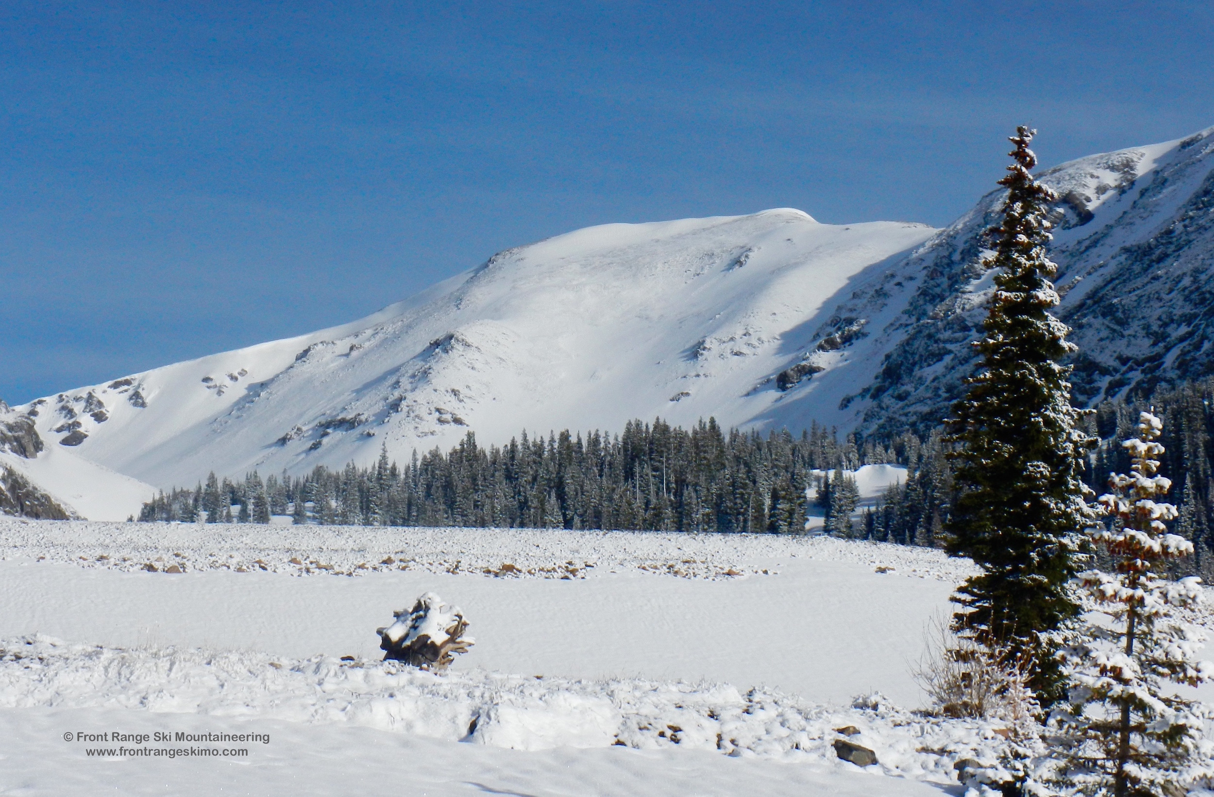
Parry Peak's Bear Claw from the Northwest. Photo: Rob Writz
Parry Peak is the highest peak in the James Peak Wilderness. The west side of the peak is highly visible from the Winter Park Ski Area, and many of the resort’s skiers and snowboarders pick out the peak’s Bear Claw as a mountaineering goal. The Southeast Slopes of Parry Peak are accessible via the Rainbow Road from Fall River. A fine ski mountaineering goal is to traverse the Continental Divide from Berthoud Pass to James Peak. The ridge is not steep, and for the majority of the winter and spring it is snow free. A very long day can include skiing the Northeast Slopes of Mount Flora, the Southeast Slopes of Parry Peak, the Bancroft Bowl, and the Southeast Slopes of James Peak.
+ ROUTES
1 – The Bear Claw
- Rating: II D5 – D10
- Season: Spring
- Exposure: Northwest
- Vertical: 2,000’
- Approach Elevations: 9,410’ - 13,100’
- Approach Distance: From Frasier River TH: 3 Miles
- Top of Route Waypoint: 39.838, -105.7133
The Bear Claw is a series of chutes lining the Northwest Face of Parry Peak. Sometimes called the “Baseball Mitt”, this face is seen by thousands of skiers at the Winter Park ski area each year. It is not frequently skied because it is challenging to access. The chutes themselves vary in steepness with the far skier’s right chute being moderate (D5) and the center chutes much steeper (D10). There is a flat bench between the center chutes and the summit and this makes a summit descent problematic, as snow does not accumulate here. It might be possible to ski from the summit to the skier’s left chutes after a strong upslope storm.
There are a few options to access the Bear Claw. The most direct is from the Frasier River Trailhead described below. Go south from the parking area and parallel the river on your right to reach Parry Creek. [39.8571, -105.7483] Follow the path of Parry Creek 2.2 miles from the trailhead to the base of the Bear Claw. There is no trail on this approach and at best you can find a moose trail. Ideally you are doing this approach on snow, otherwise prepare for slow going in the forest around Parry Creek due to the vast amount of fallen trees. Two other alternatives to approach the Bear Claw are via the North Face from Jim Creek Road or enjoy a high traverse on the Continental Divide from Berthoud Pass. The traverse from Berthoud Pass is approximately 6.5 miles and includes Colorado Mines Peak, Mount Flora, and Mount Eva.
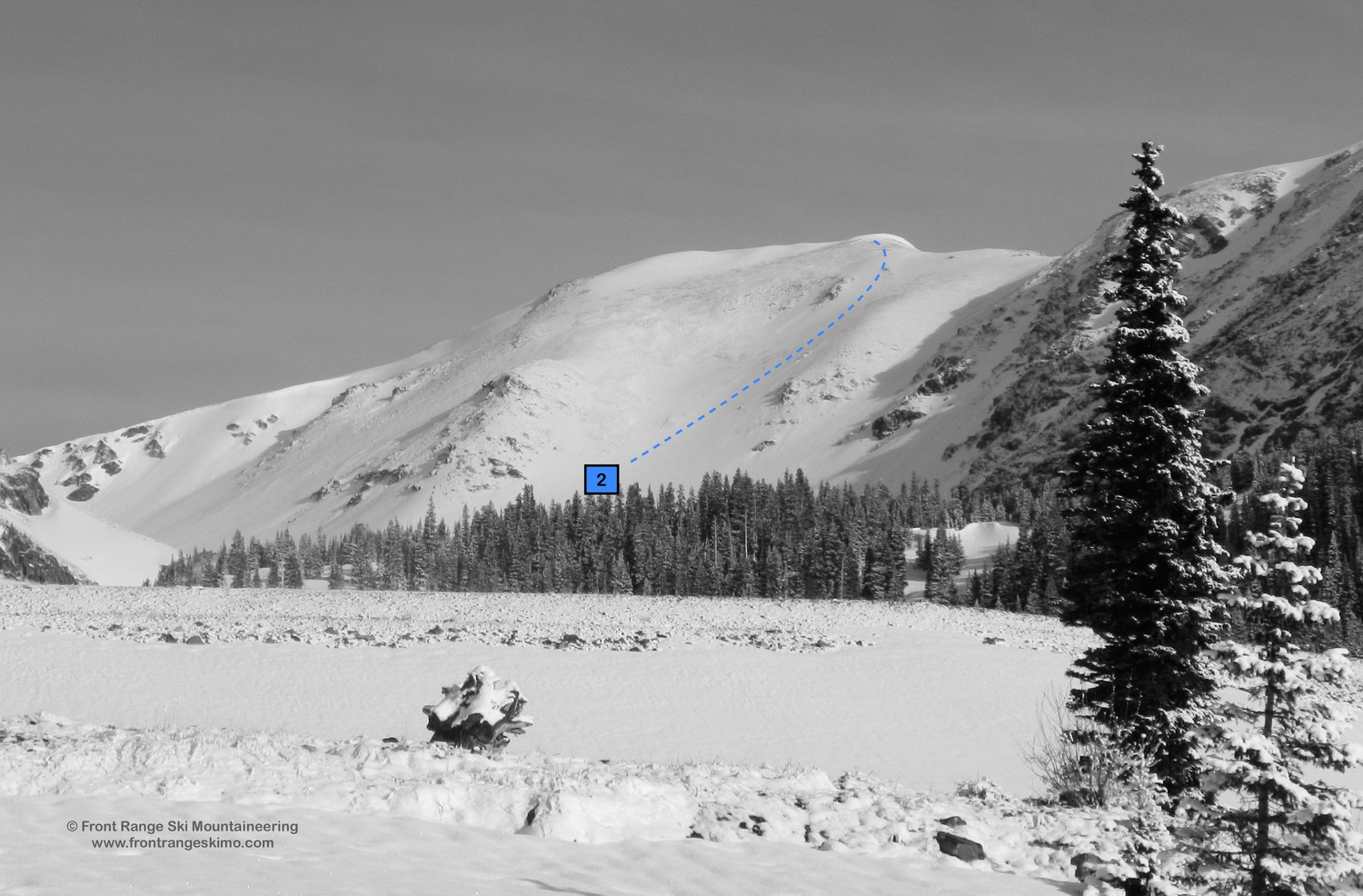
2– Southeast Slopes
- Rating: D5
- Season: Spring
- Exposure: Southeast
- Vertical: 2,000’
- Approach Elevations:
- Approach Distance: From Continental Divide TH: 3.25Miles
- Top of Route Waypoint: 39.838, -105.7133
The Southeast Slopes of Parry Peak looks like a stellar ski descent from afar. A closer look reveals a windswept face that has trouble holding a consistent snowpack for most of the winter. It takes several upslope spring storms to fill in these slopes, and even then skiers and snowboarders will need to be creative to link up some of the snowfields. A skier’s left line from the summit towards the saddle with Bancroft is one of the more reliable lines. Some years you can ski from the summit all the way to Fall River Reservoir.
From the Continental Divide Trailhead on Rainbow Road hike seven tenths of a mile to the intersection with the Chinns Lake Road. Continue on the Rainbow Road one mile to the Fall River Reservoir. [39.8215, -105.6904] Hike north along the dam into the forest and then another mile northwest and west to the base of the Southeast Slopes.
+ TRAILHEAD
Frasier River (9,410’)
The Frasier River trailhead is accessed from Highway 40 2 miles south of Winter Park. Follow Forest Road 128 east and then north two tenths of a mile to a right turn to Road 128.3. Turn right and follow this a half mile to a dead-end near the Frasier River Diversion dam. [39.8621, -105.7491] There is no formal trailhead here. It is a location to park and launch into the heinous approach to the Bear Claw.
Rainbow Road Continental Divide Trail (10,225’)
There are two possible trailhead points on the Rainbow Road depending on the snow conditions and private land. This road is located 6.6 miles from the Fall River Road exit 238 on Interstate 70. Follow the Fall River Road 6.6 miles to the major switchback. Exit the paved road and go straight on the dirt Rainbow Road. [39.8042, -105.6419] The majority of this road is in private land. Please respect this private land and do not park on the edges of the road that borders this property. The best options for parking are at the Rainbow Road and Fall River Road junction, at the first switchback, at the intersection with the Continental Divide Trail [39.8112, -105.6673] or at the Chinns Lake Road intersection [39.8153, -105.6775]. The snow and your tolerance for rock crawling will dictate where you park. In the late spring you can usually get a high clearance four-wheel drive to the intersection with the Continental Divide Trail.
+ MAPS & PICTURES
Below we have included a link to Front Range Skimo's master map. The routes on the map are approximations, and are not intended for use as a GPX track. To the right are a curated list of photos of the mountain.

Clicking on map above will open interactive Caltopo map website.