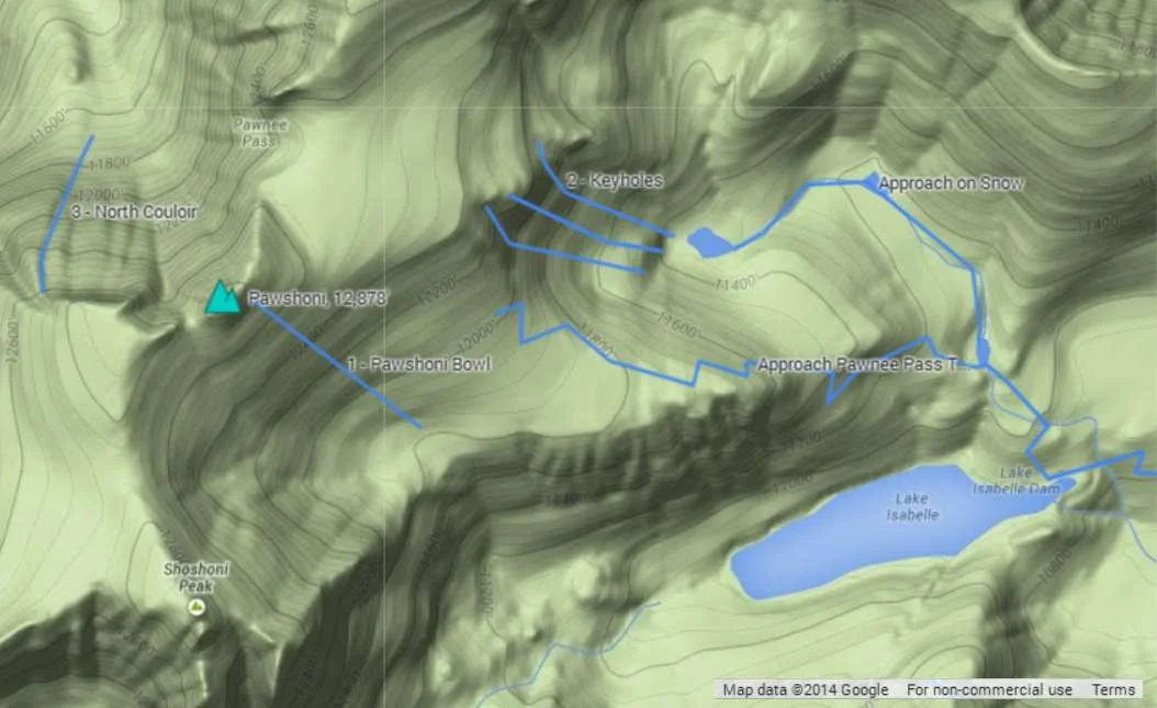
Pawshoni, 12,878'
Pawshoni from the East (S1 is the route on Shoshoni). Photo: Rob Writz
Pawshoni, or Point 12,878 is really an extension of Shoshoni Peak. It is the rise several hundred feet south of Pawnee Pass that the forms the northern end of a large bowl extending from Shoshoni. For the purpose of this website we consider it a distinct peak because it has several interesting routes that stand on their own from the neighboring mountains. Most backcountry travelers see Pawshoni from the east, and rarely see the dramatic rise of Pawshoni south of Pawnee Lake on the west side of the Continental Divide.

Shared Approach
From the Long Lake Trailhead, ski or hike southwest about two tenths of a mile to Long Lake on the Pawnee Pass Trail. Follow the trail west, or the approximate path of the trail if snow covered, along the north side of Long Lake about 2 miles to Lake Isabelle.
Route 1 - Pawshoni Bowl
- Rating: II D4
- Season: Spring
- Exposure: Southeast
- Vertical: 1,000'
- Approach Elevations: 10,080' - 12,878'
- Approach Distance: From Long Lake TH: 4 miles, From Brainard Lake Gateway TH: 7 miles
The Pawshoni Bowl is the north end of a large cirque containing this route and the Shoshoni Bowl. This face is wide enough to offer several different lines and it can easily be combined with Shoshoni Bowl, Keyholes, and Pawnee Peak for more runs. If you are done skiing for the day and leaving from the bottom of this route do not ski into the cirque drainage heading southeast towards Lake Isabelle. The bottom of this cirque is rocky, thin, and cliffed out. Retrace your entrance or the approximate line of Pawnee Pass Tail and stay north of the large cliffs above Lake Isabelle.
From the east end of Lake Isabelle, look for the approximate line of the Pawnee Pass trail switch backing to the north. Follow this to a small tarn at 11,100'. From here you can follow the line of the Pawnee Pass Trail west through steep terrain to the bottom of the bowl at 11,800'. If the terrain is snow covered, an alternative is to continue north and northwest up the drainage just over a third of a mile to a small tarn at 11,200' and then a third mile west to the final tarn in this basin. From here you can climb southwest about 550 vertical feet to the flat area and the bottom of the bowl at 11,800'. Climb up the bowl from here or proceed to Pawnee Pass and climb southwest to Point 12,878.
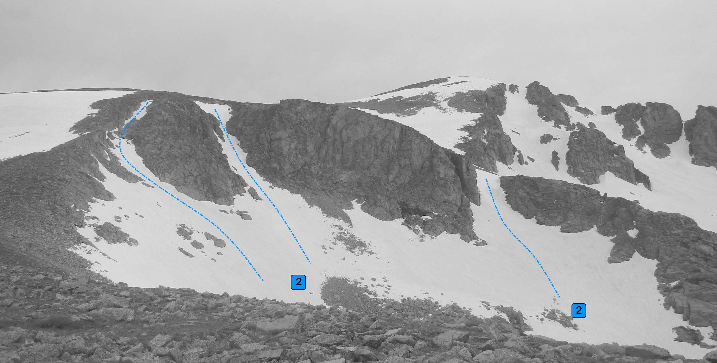
Route 2 - Keyholes
- Rating: II D5 - D8
- Season: Spring
- Exposure: East
- Vertical: 1,000'
- Approach Elevations: 10,080' - 12,400'
- Approach Distance: From Long Lake TH: 3.4 miles, From Brainard Lake Gateway TH: 6.4 miles
The Keyholes are three small couloirs running off of an east facing cirque. These are arguably part of Pawnee Peak, but we'll assign it to Pawshoni to spice things up. The left couloir (D8) may connect via snow to the top of Pawshoni Bowl via a long traverse. The middle couloir (D7) is just skiers left of this and the middle of it frequently has a rock splitting it into two channels. The right couloir (D5) is less steep and wider, and with a little bit of extra effort it can be combined with a descent from Pawnee Peak.
From the east end of Lake Isabelle, look for the approximate line of the Pawnee Pass trail switchbacking to the north. Follow this to a small tarn at 11,100'. From here you can follow the line of the Pawnee Pass Trail west through steep terrain to 11,800', and then continue on trail towards Pawnee Pass and to the top of the Keyholes. If the terrain is snow covered, an alternative is to continue north and northwest up the drainage from the tarn at 11,100’ just over a third of a mile to a small tarn at 11,200' and then a third mile west to the final tarn in this basin near 11,400'. This puts your right below the Keyholes.
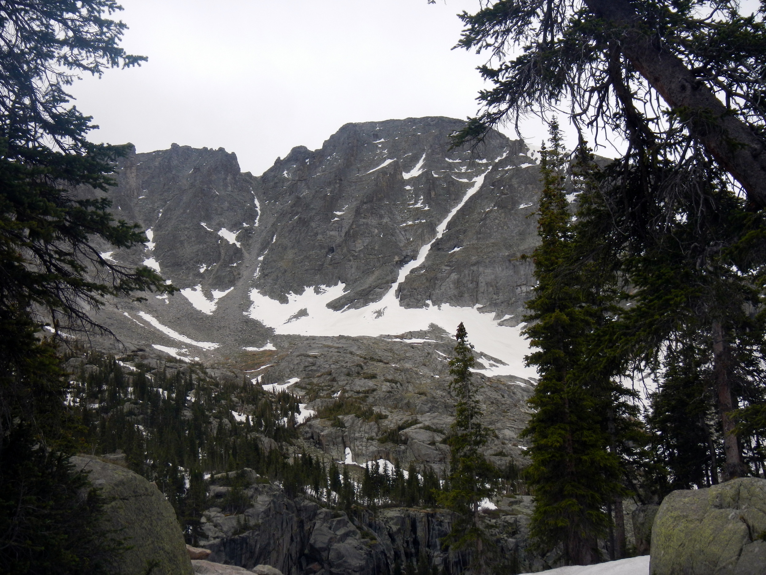
Pawshoni North Couloir. Photo: Rob Writz
Route 3 - North Couloir
- Rating: III D6
- Season: Spring, Summer
- Exposure: North
- Vertical: 800'
- Approach Elevations: 10,080' - 12,800'
- Approach Distance: From Long Lake TH: 5.25 miles, From Brainard Lake TH: 7.9 miles
Pawshoni’s North Couloir sits on the west side of the Continental Divide. The dark rock walls surrounding couloir and Pawnee Pass are reminiscent of the landscape in Lord of the Ring’s Mordor. Ominous sentinel towers greet you when you crest the pass, and the cliffs between Pawnee Pass and the North Couloir are intimidating. The couloir itself is a distinct, straight, and fun chute that climbs moderately from the Pawnee Lake basin to about 12,800’. There is some cross loading in the chute that may result in double fall line waves near the bottom.
Climbing over Pawnee Pass to the bottom of this couloir is no fun, but it is difficult to find from the summit of Pawshoni. Follow the approach described for Pawshoni Bowl. At Pawnee Pass, carefully descend the steep, rocky, and loose face to about 11,600’. The couloir stays hidden on your left until about this elevation. If you come over here early in the spring you will troubleshoot where the switch backing trail is as it is hidden in a few snow slopes. Later in the spring this side of the pass melts quickly. At the top of the couloir you can continue up and left to a short and much steeper headwall that takes you to the gentle upper north slopes of the peak

Brainard Lake Gateway Trailhead (10,080’) and Long Lake Trailhead (10,520’)
Brainard Lake Gateway Trailhead is the access point to the Mitchell Lake and Long Lake Trailheads. The road from the Gateway Trailhead to Mitchell Lake and Long Lake may not be open to cars until mid-June. Because of this closure the spring and early summer ski adventures in the Brainard Lake area are launched from here. The spacious trailhead at the Gateway is host to a large gathering of backcountry skiers and mountaineers in the pre-dawn hours on spring weekends. When the road opens in mid-June there is an access fee into the Brainard Lake Recreation Area. Access the Brainard Lake Gateway Trailhead on Brainard Lake Drive west of the town of Ward on Highway 72.
Gear up and ski, hike or ride your bike to the Long Lake Trailhead. It is about 3 miles from the Gateway on the Brainard Lake Road to the right turn leading to the Mitchell Lake Trailhead and the Long Lake Trailhead. Go about one eighth of a mile up this road and turn left and go another quarter mile to Long Lake Trailhead (straight goes to the Mitchell Lake Trailhead). You can check the status of the Brainard Lake Road at the USFS Roosevelt National Forest Boulder Ranger District Road Status website. The commitment grades below assume you are starting from the Brainard Lake Gateway and riding your bike in on a mostly dry road.

Clicking on map above will open interactive Google map website